Viking Bergen Island
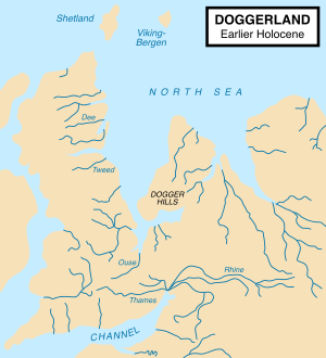
Viking–Bergen is the name of a hypothetical former island between modern Scotland and Norway, at the boundary of the North Sea, and Norwegian Sea.[1] The area is now known as the "Viking–Bergen banks" (combining the Viking and Bergen ocean banks).
During the Bølling–Allerød Period, known in Britain as the Windermere interstadial, the northern coast of Doggerland began to recede as global sea levels rose. There may have been a Shetland island marking the northern end of a bay north of the Dogger Hills, and the Viking–Bergen island would have been between the bay and the Norwegian Trench.
A more recent hypothesis is that much of the land was inundated by a tsunami around 8200 BP (6200 BC), caused by a submarine landslide off the coast of Norway known as the Storegga Slide. This theory suggests "that the Storegga Slide tsunami would have had a catastrophic impact on the contemporary coastal Mesolithic population. [...] Following the Storegga Slide tsunami, it appears, Britain finally became separated from the continent and, in cultural terms, the Mesolithic there goes its own way."[2]
See also
References
- ↑ Doggerland: the cultural dynamics of a shifting coastline
- ↑ Bernhard Weninger et al., The catastrophic final flooding of Doggerland by the Storegga Slide tsunami, Documenta Praehistorica XXXV, 2008