Vigneulles-lès-Hattonchâtel
| Vigneulles-lès-Hattonchâtel | |
|---|---|
|
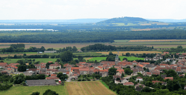
Vigneulles from Hattonchâtel | |
 Vigneulles-lès-Hattonchâtel | |
|
Location within Lorraine region  Vigneulles-lès-Hattonchâtel | |
| Coordinates: 48°58′55″N 5°42′15″E / 48.9819°N 5.7042°ECoordinates: 48°58′55″N 5°42′15″E / 48.9819°N 5.7042°E | |
| Country | France |
| Region | Lorraine |
| Department | Meuse |
| Arrondissement | Commercy |
| Canton | Vigneulles-lès-Hattonchâtel |
| Intercommunality | Communauté de communes du pays de Vigneulles les Hattonchâtel |
| Government | |
| • Mayor (2008–2014) | J.C Zingerlé |
| Area1 | 62.59 km2 (24.17 sq mi) |
| Population (2010)2 | 1,551 |
| • Density | 25/km2 (64/sq mi) |
| INSEE/Postal code | 55551 / 55210 |
| Elevation |
212–416 m (696–1,365 ft) (avg. 259 m or 850 ft) |
|
1 French Land Register data, which excludes lakes, ponds, glaciers > 1 km² (0.386 sq mi or 247 acres) and river estuaries. 2 Population without double counting: residents of multiple communes (e.g., students and military personnel) only counted once. | |
Vigneulles-lès-Hattonchâtel is a commune in the Meuse department in Lorraine in north-eastern France.
The former towns of Billy-sous-les-Côtes, Creuë, Hattonchâtel, Hattonville, Saint-Benoît-en-Woëvre, and Viéville-sous-les-Côtes were joined to Vigneulles-lès-Hattonchâtel on 1 March 1973.
Gallery
-
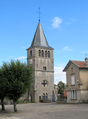
The bell tower of Vigneulles
-
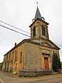
Saint-Sabastian church (Hattonville).
-
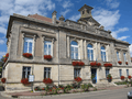
Town hall
-
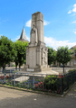
War memorial in Vigneulles
See also
- Château de Hattonchâtel
- Communes of the Meuse department
- Parc naturel régional de Lorraine
| Wikimedia Commons has media related to Vigneulles-lès-Hattonchâtel. |