Vignemale
| Vignemale | |
|---|---|
 Vignemale | |
| Elevation | 3,298 m (10,820 ft) |
| Location | |
 Vignemale | |
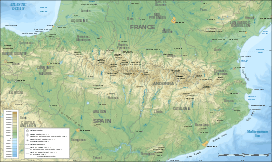
| Range | Pyrenees |
| Coordinates | 42°46′36″N 0°08′35″W / 42.77667°N 0.14306°WCoordinates: 42°46′36″N 0°08′35″W / 42.77667°N 0.14306°W |
| Climbing | |
| First ascent | August 2, 1792 |
| Easiest route | Through the Ossoue glacier |
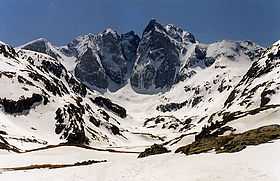
The Vignemale (Occitan: Vinhamala, Aragonese: Comachibosa), at 3,298 metres, is the highest of the French Pyrenean summits, in the border with Spain (the highest in the whole of the range is Pic Aneto).
The Vignemale is the name given to the mountain massif which actually straddles into Spain. It consists of several distinct summits, the predominant ones being Grand Vignemale or Pique-Longue (3298 m), Pointe Chausenque (3,204 m) and Petit Vignemale (3,032 m). The Vignemale is also the site of the second largest of the Pyrenean glaciers (after Aneto's one), the Ossoue (with around 0.6 km²), across which is the "voie normale" or standard route to the summit.
One of its most dramatic aspects is the North Face upon which there are a number of serious ascent routes requiring skill and commitment. Below the North Face is the impressively situated mountain refuge - the Refuge des Oulettes de Gaube. The approach from the north entails a delightful walk up to and around the picturesque Lac de Gaube giving increasingly dramatic views of the mountain.
Almost synonymous with the Vignemale is the name of Count Henry Russell, an eccentric of the Victorian era who developed a lifelong passion for the mountain.
Gallery
-
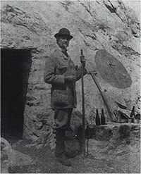
Count Henry Russell in front of one of his caves on the Vignemale
See also
