Vicars' Close, Wells

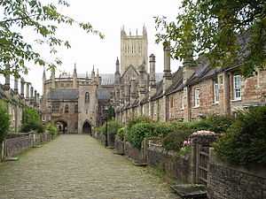
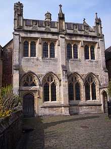
Vicars' Close, in Wells, Somerset, England, is claimed to be the oldest purely residential street with its original buildings all surviving intact in Europe.[1] John Julius Norwich calls it "that rarest of survivals, a planned street of the mid-14th century".[2] It comprises numerous Grade I listed buildings,[3][4][5][6][7][8] comprising 27 residences (originally 44), built for Bishop Ralph of Shrewsbury, a chapel and library at the north end, and a hall at the south end, over an arched gate. It is connected at its southern end to the cathedral by way of a walkway over Chain Gate.
The Close is about 460 ft (140 m) long, and paved with setts.[5] Its width is tapered by 10 ft (3 m) to make it look longer when viewed from the main entrance nearest the cathedral. When viewed from the other end it looks shorter.
By the nineteenth century the buildings were reported to be in a poor state of repair, and part of the hall was being used as a malthouse.[9]
Origins
The Close owes its origins to a grant of land and buildings by Walter de Hulle, a canon of the cathedral, for the purpose of accommodating thirteen chantry priests.[10] Bishop Jocelin styled these priests the Vicars Choral, their duty being to chant divine service eight times a day.[11][12] Previously they had lived throughout the town, and Bishop Ralph resolved to incorporate them and provide subsistence for the future. The Vicars Choral were assigned annuities from his lands and tenements in Congresbury and Wookey, an annual fee from the vicarage of Chew, and endowed them with lands obtained from the Feoffees of Walter de Hulle.[9] The residences he built became known as the College, or Close of the Vicars.[11]

The Vicars' Hall and gateway
The first part of the Close to be constructed were a first floor barrel-roofed common hall and store room below, kitchen and bakehouse which were completed in 1348.[13] Chain Gate was abutted to it in 1459 by Thomas Beckington. This included a gallery over the gate into the cathedral for the vicars' convenience. The entrance arch into the close is divided into a pedestrian gate and a waggon gate, and has a lierne vault ceiling.[8]
Vicars' Chapel and Library

The chapel was built c1424-1430 at the north end of the close against the northern boundary wall of the Liberty of St Andrew. The lower floor was a chapel, and a spiral stair led up to the library.[7] It is now used by Wells Cathedral School.[13]
The residences
The residences originally comprised a ground floor hall of approximately 20 ft x 13 ft (6 m x 4 m), and an upper floor of the same size. Both had a fireplace in the front wall. The date of some of the buildings is unclear but it is known that some had been built by 1363 and the rest were completed by 1412.[13] From the 15th century onwards many alterations have been made, including extensions at the rear and knocking through walls to create larger dwellings.[3] Following the Reformation when clerical marriage was permitted, larger households would have been required.[14] In a charter of c.1582 Queen Elizabeth restricted the number of vicars to twenty.[9]
In the fifteenth century, Bishop Thomas Beckington left much of his estate to the Vicars' Choral, enabling repairs to be carried out. The chimney shafts were renewed.[13] Each stack incorporates two heraldic shields and the upper sections of the stacks are octagonal.[3] The shields are those of the Bishop, a beacon above tun, and the arms of his three executors; sugar loaves for Hugh Sugar, three swans for Richard Swan, and the talbot for John Pope.[11][13]
No. 1 Vicars' Close was once a larger property, but has since been divided and part is now No. 1 St. Andrew Street.[3]
Shrewsbury House is architecturally different to all the other buildings. It was re-built in the 19th century after a fire that burnt down the original structure.
The gardens were not part of the original scheme. The garden walls were added in the 15th century.[5]
In 2009, two large trees that grew in the front gardens of two residences were cut down because they obscured the view, and the roots were at risk of damaging the ancient buildings.[15]
References
- ↑ Leete-Hodge, Lornie (1985). Curiosities of Somerset. Bodmin: Bossiney Books. p. 29. ISBN 0-906456-98-3.
- ↑ John Julius Norwich, The Architecture of Southern England, p. 574 (entry for Wells), Macmillan, London,1985, ISBN 0-333-22037-4
- ↑ 3.0 3.1 3.2 3.3 "Nos.1-13 Vicars Close, Wells". Images of England. English Heritage. Retrieved 2009-01-13.
- ↑ "Nos.14-27 Vicars Close, Wells". Images of England. English Heritage. Retrieved 2009-01-13.
- ↑ 5.0 5.1 5.2 "Boundary walls to Nos.1-13 Vicars Close, Wells". Images of England. English Heritage. Retrieved 2009-01-13.
- ↑ "Boundary walls to Nos.14-27 Vicars Close, Wells". Images of England. English Heritage. Retrieved 2009-01-13.
- ↑ 7.0 7.1 "The Vicars' Chapel Vicars Close, Wells". Images of England. English Heritage. Retrieved 2009-01-13.
- ↑ 8.0 8.1 "The Vicars' Hall Vicars Close, Wells". Images of England. English Heritage. Retrieved 2009-01-13.
- ↑ 9.0 9.1 9.2 Pugin, Augustus Welby; Walker, T.L. (1838). "1. The Vicar's Close, Wells, Somersetshire". Examples of Gothic Architecture III. London: Henry G.Bohn. pp. 1–28 plus 26 plates.
- ↑ Winkles, Henry; Winkles, Benjamin; Garland, Robert; Moule, Thomas (1836). Winkles's Architectural and Picturesque Illustrations of the Cathedral Churches of England and Wales. E. Wilson. pp. 103–104.
- ↑ 11.0 11.1 11.2 Davis, John; Michael, =John; Camp, Francis (1814). "IV". A Concise History of the Cathedral Church of Saint Andrew, in Wells. W.J. Quartley. pp. 18–23.
- ↑ Langley, Martin; Small, =Edwina (1990). "5". Wells. An Historical Guide. West Country Towns. Ex Libris Press. ISBN 0-948578-24-6.
- ↑ 13.0 13.1 13.2 13.3 13.4 Bush, Robin (1994). Somerset: The complete guide. Wimborne, Dorset: Dovecote Press. pp. 221–222. ISBN 1-874336-26-1.
- ↑ Scrase, Tony (1992). Wells, a pictorial history. Phillimore. ISBN 0-85033-814-X.
- ↑ "Plan submitted to demolish house and build five more". South West Business. Retrieved 7 May 2011.