Veulettes-sur-Mer
| Veulettes-sur-Mer | |
|---|---|
 | |
 Veulettes-sur-Mer | |
|
Location within Upper Normandy region  Veulettes-sur-Mer | |
| Coordinates: 49°50′52″N 0°35′49″E / 49.8478°N 0.5969°ECoordinates: 49°50′52″N 0°35′49″E / 49.8478°N 0.5969°E | |
| Country | France |
| Region | Upper Normandy |
| Department | Seine-Maritime |
| Arrondissement | Dieppe |
| Canton | Cany-Barville |
| Intercommunality | Côte d'Albâtre |
| Government | |
| • Mayor (2001–2008) | Christian Legrand |
| Area1 | 4.71 km2 (1.82 sq mi) |
| Population (2006)2 | 336 |
| • Density | 71/km2 (180/sq mi) |
| INSEE/Postal code | 76736 / 76450 |
| Elevation |
0–81 m (0–266 ft) (avg. 10 m or 33 ft) |
|
1 French Land Register data, which excludes lakes, ponds, glaciers > 1 km² (0.386 sq mi or 247 acres) and river estuaries. 2 Population without double counting: residents of multiple communes (e.g., students and military personnel) only counted once. | |
Veulettes-sur-Mer is a commune in the Seine-Maritime department in the Haute-Normandie region in northern France.
Geography
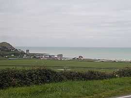
A tourism and farming village situated on the coast of the English Channel in the Pays de Caux, some 27 miles (43 km) southwest of Dieppe at the junction of the D79 and the D271. The Durdent river flows to the sea here through the pebble beach (the longest in the department at 2 km) and huge chalk cliffs which rise up to face the sea .
Heraldry
.svg.png) |
The arms of Veulettes-sur-Mer are blazoned : Azure, in fess 2 roses Or and in pale a crescent and a heart with a cross on top argent (those 4 charges in a lozenge formation), and in chief a label argent. |
Population
| Year | 1962 | 1968 | 1975 | 1982 | 1990 | 1999 | 2006 |
|---|---|---|---|---|---|---|---|
| Population | 439 | 363 | 342 | 369 | 299 | 296 | 336 |
| From the year 1962 on: No double counting—residents of multiple communes (e.g. students and military personnel) are counted only once. | |||||||
Places of interest
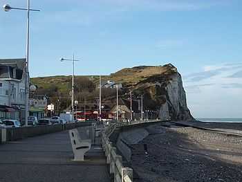
The cliffs of Veulettes
- The church of St. Valery, dating from the twelfth century.
- A sixteenth-century stone cross.
- The cliffs.
People
- Jean-Jacques Servan-Schreiber (1924–2006) journalist, essayist and politician lived here.
See also
- Communes of the Seine-Maritime department
- Seine-Maritime
- Normandy
References
External links
| Wikimedia Commons has media related to Veulettes-sur-Mer. |
- Official commune website (French)
- Veulettes-sur-Mer on the Quid website (French)