Vernon Regional Airport
"YVE" redirects here. For the given name, see
Yve.
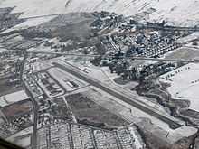
Vernon Regional Airport, (IATA: YVE, ICAO: CYVK), is a small, non-towered airport located 1.8 nautical miles (3.3 km; 2.1 mi) southwest of Vernon, British Columbia, Canada. It is one of the few airports in the Okanagan Valley that can offer skydiving due to the fact that all commercial operators must give written consent to a skydiving company for skydiving to occur, something which is not feasible at a larger airport like Kelowna International Airport.
See also
References
- ↑ Canada Flight Supplement. Effective 0901Z 24 July 2014 to 0901Z 18 September 2014
External links

 Media related to Vernon Regional Airport at Wikimedia Commons