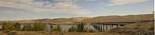
Vernita Bridge
| Vernita Bridge | |
|---|---|
 Vernita Bridge | |
| Coordinates | 46°38′32.97″N 119°43′58.09″W / 46.6424917°N 119.7328028°WCoordinates: 46°38′32.97″N 119°43′58.09″W / 46.6424917°N 119.7328028°W |
| Carries |
|
| Crosses | Columbia River |
| Characteristics | |
| Design | Steel truss concrete girder |
| Total length | 1,982 ft (604 m)[1] |
| History | |
| Opened | 1965 |
The Vernita Bridge is a bridge on Washington State Route 24 over the Columbia River between Grant County and Benton County, located approximately 10 miles (16 km) south of Desert Aire and Mattawa, Washington. The bridge is in the Hanford Reach National Monument near the Hanford Site.
References
- ↑ "SR-24 Bridge List" (PDF). Washington State Department of Transportation. June 2011. Retrieved 3 July 2011.
External links
| |||||||||