Velddrif
| Velddrif | |
|---|---|
|
Velddrif | |
 Velddrif
| |
| Coordinates: 32°47′S 18°10′E / 32.783°S 18.167°ECoordinates: 32°47′S 18°10′E / 32.783°S 18.167°E | |
| Country | South Africa |
| Province | Western Cape |
| District | West Coast |
| Municipality | Bergrivier |
| Established | 1946 |
| Area[1] | |
| • Total | 8.87 km2 (3.42 sq mi) |
| Population (2011)[1] | |
| • Total | 11,017 |
| • Density | 1,200/km2 (3,200/sq mi) |
| Racial makeup (2011)[1] | |
| • Black African | 12.2% |
| • Coloured | 57.1% |
| • Indian/Asian | 0.5% |
| • White | 29.6% |
| • Other | 0.6% |
| First languages (2011)[1] | |
| • Afrikaans | 83.5% |
| • Xhosa | 8.7% |
| • English | 5.8% |
| • Other | 2.1% |
| Postal code (street) | 7365 |
| PO box | 7365 |
| Area code | 022 |
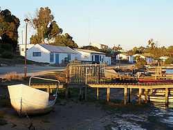
Velddrif or Velddrift (population 7800 in 2007[2]) is a coastal fishing town in the Bergrivier Local Municipality, Western Cape, South Africa. It is located on the estuary where the Berg River flows into St. Helena Bay.
Geography and environment
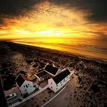
Velddrif is located approximately 145 kilometres (90 mi) north of Cape Town, and is connected to Cape Town by the R27 road.[3] The R27 joins the R399 at Velddrif. It is situated near the point that the meandering Berg River flows into the sea at St. Helena Bay. This estuary is an important bird habitat, home to around 30,000 birds, including up to 80 species which are endemic to the Cape coast.[2] Well over 350 different species of birds can be seen here as it is a habitat for sea, river and land birds.
Flowers grow in this area, including the Euclea racemosa (Kersbos), Babiana ringens (Rotstert), Willdenowia incurvata (Sonkwas Riet), Limonium (Strandroos) and Leucospermum rodolentum (Sandveld Luisebos).[2] Regular boat trips can be taken up the river to view birds.[4]
History
The name Velddrif is derived from a local farmer, Theunis Smit, who took his stock through a drift in the field (Afrikaans: veld), to find grazing across the river.[4] In 1899, a pont (pontoon ferry) was built to cross the Berg River.[4]
Economy
The fishing industry is substantial in Velddrif; the town is part of the Crayfish Route. A common scene in the area is the rickety wooden jetties with the dried fish speciality, Bokkoms hung up the dry.[2][3] The town contains Port Owen, which comprises 100 hectares and has 3.5 km of waterways. There are numerous restaurants in Velddrif and nearby Laaiplek which serve fresh fish and other seafood. The town attracts a number of tourists, especially for its wildlife, fishing, yachting and its art galleries, which represents the work of over 100 artists and craftsmen in the area.[3][4] A holiday resort has grown up around the marina area of Port Owen.[5]
The annual Berg River Canoe Marathon which starts in Paarl ends at the Carinus Bridge in Velddrif.[3][5] The first Berg River Canoe Marathon was held in 1962, and has gained a reputation for being one of the toughest courses in the world, also being the longest course in South Africa.[6]
References
- ↑ 1.0 1.1 1.2 1.3 "Main Place Velddrif". Census 2011.
- ↑ 2.0 2.1 2.2 2.3 "Velddrif". www.routes.co.za. Retrieved June 19, 2010.
- ↑ 3.0 3.1 3.2 3.3 Pinchuck, T., McCrea, B., Reid, D (2002). Rough Guide to South Africa, Lesotho & Swaziland. Rough Guides. pp. 289–90. ISBN 1-85828-853-3.
- ↑ 4.0 4.1 4.2 4.3 "Velddrif". Southern African Places. Retrieved June 19, 2010.
- ↑ 5.0 5.1 Truter, Cornel (1998). West Coast Tourist Guide. Juta and Company Ltd. p. 86. ISBN 1-919713-24-7.
- ↑ "Berg River Canoe Marathon". www.southafrica.net. Retrieved June 19, 2010.
| |||||||||||||||||||||||||||||
.svg.png)