Vayk
Coordinates: 39°41′30″N 45°27′55″E / 39.69167°N 45.46528°E
| Vayk Վայք | |
|---|---|
|
Vayk | |
 Vayk Վայք | |
| Coordinates: 39°41′30″N 45°27′55″E / 39.69167°N 45.46528°E | |
| Country | Armenia |
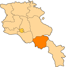
| Marz (Province) | Vayots Dzor |
| Area | |
| • Total | 3 km2 (1 sq mi) |
| Elevation | 1,300 m (4,300 ft) |
| Population (2009) | |
| • Total | 5,900 |
| • Density | 2,000/km2 (5,100/sq mi) |
| Time zone | (UTC+4) |
| Website | official website |

Vayk (Armenian: Վայք) is a town in the Vayots Dzor Province of Armenia, located on the Yerevan-Goris highway, 140 km south of the capital Yerevan and 20 km southeast of the regional capital Yeghegnadzor.[1] With an elevation of 1300 meters above sea level, Vayk is situated on the left bank of Arpa River surrounded with the Yeghegis mountains from the northwest and Vayots Dzor mountain range from the south.
General information
Historically, Vayk belongs to the Vayots Dzor canton of Syunik province; the 9th province of Greater Armenia (Armenia Major).
Tho town was known as Soylan under the Turkic rulers of Armenia. It was renamed Azizbekov between 1956 and 1990 after the Soviet revolutionary leader Meshadi Azizbekov. In 1990, the historic name of the settlement was restored.
Vayk has a popularion of 5,900 (2009 est.), occupying an urban area of 3 km².
The historic bridge of Vayk rebuilt by General Paskevich in 1827 is located at the western vicinity of the town.[2]
Gallery
-

General view
-

Saint Trdat church of Vayk
-

Arpa River at Vayk
-
.jpg)
Khachkar-memorial to Holy Resurrection
References
| |||||||||||||||||||||