Varennes-sur-Allier
| Varennes-sur-Allier | ||
|---|---|---|
|
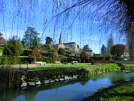
A view within Varennes-sur-Allier | ||
| ||
 Varennes-sur-Allier | ||
|
Location within Auvergne region  Varennes-sur-Allier | ||
| Coordinates: 46°18′47″N 3°24′08″E / 46.3130°N 3.4022°ECoordinates: 46°18′47″N 3°24′08″E / 46.3130°N 3.4022°E | ||
| Country | France | |
| Region | Auvergne | |
| Department | Allier | |
| Arrondissement | Vichy | |
| Canton | Varennes-sur-Allier | |
| Intercommunality | Varennes Forterre | |
| Government | ||
| • Mayor (2008–2014) | Pierre Courtadon | |
| Area1 | 24.1 km2 (9.3 sq mi) | |
| Population (2008)2 | 3,751 | |
| • Density | 160/km2 (400/sq mi) | |
| INSEE/Postal code | 03298 / 03150 | |
| Elevation |
228–292 m (748–958 ft) (avg. 248 m or 814 ft) | |
|
1 French Land Register data, which excludes lakes, ponds, glaciers > 1 km² (0.386 sq mi or 247 acres) and river estuaries. 2 Population without double counting: residents of multiple communes (e.g., students and military personnel) only counted once. | ||

Varennes-sur-Allier is a commune in the Allier department in Auvergne in central France.
Population
| Historical population | ||
|---|---|---|
| Year | Pop. | ±% |
| 1962 | 4,020 | — |
| 1968 | 4,712 | +17.2% |
| 1975 | 4,907 | +4.1% |
| 1982 | 4,751 | −3.2% |
| 1990 | 4,413 | −7.1% |
| 1999 | 4,072 | −7.7% |
| 2008 | 3,750 | −7.9% |
See also
References
| Wikimedia Commons has media related to Varennes-sur-Allier. |