Vardenis
| Vardenis Վարդենիս | |
|---|---|
|
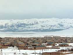
Vardenis in winter | |
 Vardenis Վարդենիս | |
| Coordinates: 40°10′50″N 45°43′12″E / 40.18056°N 45.72000°E | |
| Country |
|
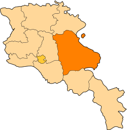
| Marz | Gegharkunik |
| Established | 1830 |
| Government | |
| • Mayor | Volodya Khloyan |
| Area | |
| • Total | 10 km2 (4 sq mi) |
| Elevation | 1,943 m (6,375 ft) |
| Population (2009) | |
| • Total | 12,700 |
| Time zone | GMT+4 |
| Area code(s) | +374 (269) |
| Sources: Population [1] | |
Coordinates: 40°10′50″N 45°43′12″E / 40.18056°N 45.72000°E Vardenis (Armenian: Վարդենիս), is a town in the south-eastern corner of Gegharkunik province (marz) of the Republic of Armenia. The current territory of Vardenis was formerly known as Vasakashen, Voskeshen, and later Basargechar, until 1969 when it was renamed Vardenis.
The town is located in the valley of the Masrik river, on the territory of the Masrik artesian basin at 1,943 metres (6,375 feet) above sea level. It is 170 kilometres (110 miles) from the capital Yerevan, and 75 kilometres (47 mi) from the provincial centre Gavar. The administrative territory of Vardenis comprises 3,006 hectares (7,430 acres), of which 736 hectares (1,820 acres) is occupied by the town itself. Vardenis got its status as an urban settlement in 1995.
Geography
Topography
Vardenis is located on the slopes of the 82-kilometre (51 mi) range of Vardenis mountains. The highest peak, also named Vardenis, is 3,522 metres (11,555 ft) above sea level. To the north-east, west and south-east of the town there are numerous roads to different parts of Armenia. The town is also bordered by the range of Sevan mountains. Vardenis is 5 kilometres (3 mi) from Lake Sevan and it is directly affected by its proximity.
Geology
The town of Vardenis is situated on the Masrik plain, in the valley of Masrik river. From the north it is bordered by Lake Sevan, from the east by Zangezur mountains and from the south-east by Vardenis mountains. From morphological point of view, Masrik represents an intermontane area filled with fluvial-lacustrian deposits. The major part of the city, i.e. alluvial-proluvial-accumulative plain, is presented by claysands, clays, sands, several subsoils. The south-eastern part of the town sits on erosion-denudational slopes, presented by slightly eroded, poriferous basalt. On the whole territory of Vardenis there are no active tectonic rifts. The projected earthquake acceleration varies between 0.28 and 0.32g. In the city centre, the acceleration is 0.32g (8.5 magnitude), in the southern and eastern parts the magnitude reaches up to 8.25-8.5.
The town is at the proximity of Sevan National Park which is very rich in biodiversity.
Mineral resources
The area of Vardenis is rich with metal and non-metal resources. The gold mine of Sotk is active. There are numerous types of rock used in construction, as well as mines of semi-precious stones.
The Zangezur range is made up of paleogenic granitoids, volcanic and sedimentary deposits. In general, Syunik region is rich in mineral resources, including stones and metals.
The mineral resources of Vardenis can be classified as follows:
| Mineral Resource | Location |
|---|---|
| Limestone | |
| Travertines | |
| Marble | |
| Clays | |
| Vulcanic auriferous pumice | |
| Semiprecious stones | |
| Auriferous peat | |
| Auriferous gray coal | |
| Magnesium ore | |
| Chromite ore | |
| Nikel and cobalt ore | |
| Mercury ore | |
| Copper | |
| Mixed metal ore | |
| Platinum | |
Water resources
Gegharkunik province is rich in water resources (surface, ground fresh and mineral waters). Water resources of the whole province comprise about 692,000 cubic metres (24,400,000 cu ft) per day. Water resources of the Vardenis area amount to about 248 cubic metres (8,800 cu ft) a day, of which about 115 cubic metres (4,100 cu ft) a day are subject to use.
Masrik river runs through the northern part of the city. The horizon of the ground waters of this artesian basin lies 1.5-5m deep, which together with the horizon of weak pressured waters creates a joint water-bearing horizon. The fluctuations in the water level are between 0.24m and 0.57m.
Water in Vardenis is supplied by "Akunk", "Shat Jrer" and "Akner" water-pipe systems. The pipes of inner system and captation are currently in quite poor technical and sanitation condition.
Climate
Vardenis is 1,943 metres (6,375 ft) above sea level, with mild summers and cold winters. The average winter temperature is −6 °C (21 °F). The winter actually lasts for six months, and the number of days with temperatures below zero prevail. The snow falls in November and melts in mid-April. Vardenis is known for high insolation with 2,500 to 2,700 hours annually. Precipitation comprises 400 to 500 millimetres (16 to 20 in). The number of blizzard days is 30, of which 13 are in January.
The summer is short and mild, sunny, relatively humid, with minimal precipitation. The average minimum temperature of July–August is 16 °C (61 °F). while the maximum makes up to 35 °C (95 °F). Wind direction in the town and the whole region is stable. Eastern winds prevail during the whole year. The autumn is mild, first half is moderately cloudy, the second half is unstable.
Meteorological observations of the town (air temperature, precipitation, atmospheric pressure, relative humidity, absolute humidity, wind direction and speed etc.) are implemented by Vardenis-Masrik meteorological stations, established in the 1940s at 1,842.7 metres (6,046 ft) above sea level.
Historical and cultural heritage
The current territory of Vardenis (formerly named Vasakashen, Voskeshen, Basargechar) occupies part of the historic Sotk canton of Syunik Province. According to legends, the settlement was founded by Gegham, the grandson of the legendary Hayk and named Geghamabak. According to the historian Ghevond Alishan, Gaburn Vasak, the prince of Syunik, founded a settlement on this territory in the 9th century AD. which was known as Vasakashen until the 17th century. After the fall of the Arshakuni dynasty, the county of Sotk was transferred to the dynasty of Smbatyan, prince of Vaykunk (Tsar) in the county of Artsakh. During the raids of various nomadic tribes, the settlement was renamed Basargechar (perhaps meaning "trodden and passed", or related to the name "Basar", presumably of one of the leaders). In the 19th century, many Armenians from the area migrated to Georgia. In 1829–1830, the settlement was re-inhabited by Armenian migrants from Diadin (Tateon) in Western Armenia. From 1930 to 1995 it was an administrative centre. In 1969 the name was changed from Basargeshar to Vardenis. The first general urban plan of Vardenis was applied in 1952. The updated plan of the town, including the community lands, was developed by the requirement of the Ministry of Urban Planning of the Republic of Armenia in 2004.
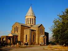
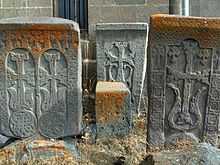
Vardenis is one of the oldest settlements in Armenia. The town and its vicinities are rich in cultural heritage with 568 monuments recorded. The most interesting are Makenats monastery, the basilica in Sotk, the chapels of Ayrk, Karchaghbyur, as well as numerous other chapels, the tombs of 3rd-1st millennia BC, the Cyclopean masonry, and the medieval khachkars (cross-stones). In the centre of Vardenis, there is the Church of Surp Astvatsatsin (Holy Mother of God), built in 1905, where the Armenian historian Hovhannes Tsaretsi worked. The church is surrounded with numerous khachkars dating back to the 14th and the 17th centuries.
Population and economy
During the Soviet period the Vardenis region had a mixed population of Armenians and Azerbaijanis. In 1988, as a result of the conflict between Azerbaijan and Armenia, its ethnic Azeri population was expelled and was replaced by ethnic Armenians. According to the 2001 census, the population of Vardenis comprised 13,700. Deterioration of economic potential, difficult financial situation, high unemployment rates and other problems resulted in decrease of the population. In comparison with 1996, the population has decreased by 2250 people, mainly due to youth migration and consequently, low birth rates.
The population is mainly engaged in agriculture, trade and services. The Sotk gold mine which is considered to be one of the largest deposits in Armenia is located 20 kilometres (12 miles) east of the city. Many small dairy and bakery enterprises are still functioning in Vardenis since the Soviet times.
Education and sports
Vardenis has four public education schools and three kindergartens. The town is also home to the house-museum of Viktor Hambardzumyan whose father philologist "Hamazasp Hambardzumyan" was a native of Varden
Sister City
Football club Lernagorts Vardenis was the only club of the town. It was forced to dissolve in 1995 due to financial difficulties.
References
- Vardenis at GEOnet Names Server
- REC Caucasus. 2009. Report on the Status of Environmental Situation in Vardenis.
- World Gazeteer: Armenia – World-Gazetteer.com
- Report of the results of the 2001 Armenian Census, National Statistical Service of the Republic of Armenia
- Brady Kiesling, Rediscovering Armenia, p. 47; original archived at Archive.org, and current version online on Armeniapedia.org.
- Հայկական սովետական հանրագիտարան. Armenian Soviet Encyclopedia