Vardø Lighthouse
 | |
 | |
| Location | Hornøya, Vardø, Norway |
|---|---|
| Coordinates | 70°23′20″N 31°09′30″E / 70.38889°N 31.15833°ECoordinates: 70°23′20″N 31°09′30″E / 70.38889°N 31.15833°E |
| Year first constructed | 1896 |
| Automated | 1991 |
| Construction | Wood |
| Tower shape | Square pyramid |
| Markings / pattern | White |
| Height | 20 metres (66 ft) |
| Focal height | 77.2 metres (253 ft) |
| Intensity | 1,809,000 candela |
| Range | 23 nmi (43 km; 26 mi) |
| Characteristic | Fl W 30s |
| Admiralty number | L4210 |
| NGA number | 14616 |
| ARLHS number | NOR-267 |
| Norway number | 968500 |
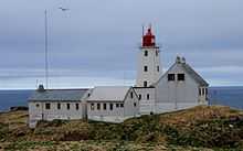
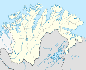
Vardø Lighthouse (Norwegian: Vardø fyr) is a coastal lighthouse located on the island of Hornøya, just off the coast of the town of Vardø in Vardø Municipality in Finnmark county, Norway. This is the easternmost lighthouse in Norway.
Description

It was established in 1896 and automated in 1991. The lighthouse was listed as a protected site in 1998.[1][2]
The 20-metre (66 ft) tall white, square pyramidal, wooden tower has a red, metal, cylindrical light room on top. The light emits a white flash every 30 seconds. The 1,809,000 candela light can be seen for up to 23 nmi (43 km; 26 mi). The light is emitted at an altitude of 77.2 metres (253 ft) above sea level.
The light burns from 12 August until 24 April each year, but it is off during the summers due to the midnight sun. The site is located on a rocky island, just off the Vardø harbor. It is only accessible by boat, and it is closed to the public.[1][3]
See also
References
- ↑ 1.0 1.1 Henriksen, Petter (ed.). "Vardø fyr". Store norske leksikon (in Norwegian). Oslo: Kunnskapsforlaget. Retrieved 13 December 2011.
- ↑ Kystverket (2012). Norske Fyrliste 2012 (PDF) (in Norwegian). ISBN 9788245013542.
- ↑ Rowlett, Russ (19 July 2011). "Lighthouses of Norway: Hammerfest Area". University of North Carolina at Chapel Hill. Retrieved 2013-02-28.
External links
 Media related to Vardø fyr at Wikimedia Commons