Vancouver Harbour Water Airport
| Vancouver Harbour Water Airport Vancouver Coal Harbour Seaplane Base | |||||||||||
|---|---|---|---|---|---|---|---|---|---|---|---|
_overview.jpg) | |||||||||||
| IATA: CXH – ICAO: CYHC | |||||||||||
| Summary | |||||||||||
| Airport type | Public | ||||||||||
| Operator |
West Coast Air, Harbour Air Services, Vancouver Harbour Float Centre | ||||||||||
| Serves |
Vancouver, British Columbia | ||||||||||
| Location |
Coal Harbour, Burrard Inlet | ||||||||||
| Time zone | PST (UTC−08:00) | ||||||||||
| • Summer (DST) | PDT (UTC−07:00) | ||||||||||
| Elevation AMSL | 0 ft / 0 m | ||||||||||
| Coordinates | 49°17′40″N 123°06′41″W / 49.29444°N 123.11139°WCoordinates: 49°17′40″N 123°06′41″W / 49.29444°N 123.11139°W | ||||||||||
| Map | |||||||||||
 CYHC Location in Vancouver | |||||||||||
| Runways | |||||||||||
| |||||||||||
| Statistics (2012) | |||||||||||
| |||||||||||
Vancouver Harbour Water Airport or Vancouver Coal Harbour Seaplane Base (IATA: CXH, ICAO: CYHC) is located at Coal Harbour in Vancouver, British Columbia, Canada. The airport is within walking distance of the HeliJet heliport and Waterfront Station, a public transit hub in Downtown Vancouver.
It is classified as both an airport and an airport of entry by NAV CANADA and is staffed by the Canada Border Services Agency. CBSA officers at this airport currently can handle general aviation aircraft only, with no more than 15 passengers.[1]
Control tower
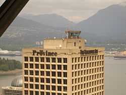
The Vancouver Harbour Control Tower is the only one in Canada specifically for a water aerodrome. At 142 m (466 ft) above ground it is the highest control tower in the world.[3][4] and is located on top of the Granville Square building. In 2009 the airport handled 54,741 aircraft movements, the 35th busiest in Canada.[2] It is also the 8th busiest aerodrome in BC and the busiest water aerodrome in Canada. Itinerant aircraft movements (from one airport to another) for the aerodrome were 54,711 while local movements were 30.[2]
Operations

The actual aircraft docking area, at 49°17′26.44″N 123°07′08.90″W / 49.2906778°N 123.1191389°W, is situated just west of Canada Place. This part of Vancouver harbour is listed by NAV CANADA as a restricted area and no aircraft are permitted to take off, land or move through the zone at a high speed. Just north of Canada Place is a rectangular section called "Area Alfa", centered on the official coordinates, which is the main aircraft operating zone.[1]
In 2007, the link to Victoria Inner Harbour Airport was, according to the Official Airline Guide, Canada's busiest air route by the number of weekly flights.[5]
Airlines and destinations
| Airlines | Destinations |
|---|---|
| Harbour Air | Bedwell Harbour, Ganges, Maple Bay, Nanaimo Harbour, Sechelt, Victoria Harbour |
| Helijet | Victoria Harbour, Vancouver Airport, province-wide medevac service |
| Salt Spring Air | Bedwell Harbour, Ganges, Maple Bay, Patricia Bay, Victoria Harbour |
| Seair Seaplanes | Nanaimo Harbour |
| West Coast Air | Victoria Harbour, Nanaimo Harbour, Comox |
| Whistler Air[6] | Seasonal: Whistler/Green Lake |
See also
- Vancouver Harbour Control Tower
- List of airports in the Vancouver area
References
- ↑ 1.0 1.1 1.2 Canada Flight Supplement. Effective 0901Z 24 July 2014 to 0901Z 18 September 2014
- ↑ 2.0 2.1 2.2 Total aircraft movements by class of operation — NAV CANADA towers
- ↑ Nav Canada Towers–Big and Small
- ↑ Vancouver Harbour ATC
- ↑ OAG reveals latest industry intelligence on the busiest routes
- ↑ http://www.whistlerair.ca/
External links
- CXH - Vancouver, British Columbia (Coal Harbour SPB)
- Accident history for CXH: Vancouver-Coal Harbour SPB at Aviation Safety Network
| ||||||||||||||||||||||||||||||