Vanadzor
| Vanadzor | ||
|---|---|---|
|
Vanadzor City landmarks Vanadzor skyline • Pambak River Holy Mother of God church • Russian church of the Nativity Lori Province administration • Hayk square Panorama of Vanadzor | ||
| ||
 Vanadzor | ||
| Coordinates: 40°48′46″N 44°29′18″E / 40.81278°N 44.48833°E | ||
| Country |
| |
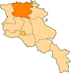
| Marz | Lori | |
| Founded | 1828 | |
| Government | ||
| • Mayor | Samvel Darbinyan | |
| Area | ||
| • Total | 25.1 km2 (9.7 sq mi) | |
| Elevation | 1,350 m (4,430 ft) | |
| Population (2011) | ||
| • Total | 105,000 | |
| • Density | 4,200/km2 (11,000/sq mi) | |
| Demonym | Vanadzortsi | |
| Time zone | GMT (UTC+4) | |
| Postal code | 2001-2024 | |
| Area code(s) | (+374) 322 | |
| Vehicle registration | 36 | |
| Website | Vanadzor official website | |
| Sources: Population[1] | ||


Coordinates: 40°48′46″N 44°29′18″E / 40.81278°N 44.48833°E Vanadzor (Armenian: Վանաձոր) is the third-largest city in Armenia and the capital of the Lori Province in the northern part of the country. It is located around 128 kilometres (80 miles) north of the capital Yerevan. As of the 2011 official estimate, the city had a population of 105,000, down from 148,876 reported at the 1979 official census. The city was known as Gharakilisa (Karakilisa) during the Russian rule. After the Sovietization of Armenia, the city was renamed Kirovakan (Armenian: Կիրովական) in 1935, after the Bolshevik leader Sergey Kirov. After the independence of Armenia, Kirovakan was renamed Vanadzor in 1992.
The city is in a picturesque setting, with an attractive planned town centre. Mostly crumbling Soviet-era chemical factories dominate much of the valley below the city.
History


The area of present-day Vanadzor has been settled since the Bronze Age, based on the tombs and other historic remains found on the nearby hills of Tagavoranist and Mashtots. During the ancient Armenian kingdoms, the area was considered as part of the Tashir canton of Gugark; the 13th province of the Kingdom of Armenia (Armenia Mayor), until the end of the Artaxiad Dynasty's rule over Armenia in the 1st century AD. Later, the region was ruled by the other Armenian dynasties of the Arsacids and the Bagratunis. By the end of the 10th century, the area became part of the Kingdom of Lori (Kingdom of Tashir-Dzoraget) until the beginning of the 12th century. With the invasion of the Seljuk Turks, the region became under the rule of the Great Seljuk Empire. The settlement was called Gharakilisa (meaning the black church in Turkic) by the Seljuks possibly as early as the 13th century, from the black-stoned Armenian church of the Holy Mother of God, on the nearby hill.
In 1801, the entire region of Lori became part of the Russian Empire along with the Georgian state, a fact that made Lori one of the strategically important territories for the Russian defensive forces on the border against Persia. In 1826, the settlement of Gharakilisa was entirely destroyed by Hasan Khan during the Russo-Persian war. In 1828, the Russians founded a new town to become a major centre for the deployment of their troops during the Russo-Turkish War of 1828–29. According to Khachatur Abovian, the population of Gharakilisa was not more than 600 by the end of the 1820s, mainly migrants from Yerevan. In 1849, it became part of the Erivan Governorate within the Russian Empire. Under the new administrative status, Gharakilisa was flooded with many hundreds of migrating Armenian families from Kars, Ardahan and Western Armenian cities of Karin and Daroynk (Doğubeyazıt).
The town enjoyed considerable uplift through the opening of the railroad towards Tbilisi in 1899. The vicinity of the town had become site of the Battle of Karakilisa in May 1918, when General Tovmas Nazarbekian's outnumbered troops, led by Garegin Nzhdeh successfully defended the region from the invading Turkish Army, pushing them back just few days after the crucial Armenian victory in the Battle of Sardarapat, thus allowing the Republic of Armenia to come into existence.[2] On the North side of the Spitak-Vanadzor highway, about 2 km (1 mi) West of the city, there is a little shrine in the ruins of a church, site of a planned monument to that battle.

However, after 2 years of brief independence, Armenia fell under the Soviet rule. The first city development plan of Gharakilisa initiated by architects Karo Halabyan, Mikayel Mazmanyan and Gevork Kochar, was adopted in 1929–1930. Under the new plan, the town was enlarged towards the eastern and western parts. In 1935, the Soviets renamed the city Kirovakan after the Bolshevik leader Sergey Kirov. In 1939, the new remodeling plan of the city created by architects N. Zargaryan and A. Minasyan was introduced to create an industrial district and a summer-resort area. The centre of the city was redeveloped during the 1950s. The central town square named after S. Kirov was opened along with the surrounding government and administrative buildings.
After the independence of Armenia, Kirovakan was renamed Vanadzor after the Vanadzor River which flows through the city.
Vanadzor, along with Gyumri and Spitak (25 km (16 mi) west), suffered a considerable amount of damage from the 1988 earthquake when 564 residents died in the city. Unlike the two other cities, the majority of buildings in Vanadzor were unscathed from the earthquake.
Geography and climate
Vanadzor, the capital of Lori Province, is located 128 km (80 mi) north of Yerevan and 64 km (40 mi) east of Gyumri.
At an average height of 1350 meters above sea level, Vanadzor is located in the valley of Pambak River, on the point where the rivers of Tandzut and Vanadzor join the Pambak river. The city, is surrounded with the over 2500-meters high mountains of Bazum and Pambak. The southern and eastern regions are densely forested while to the north and west are only covered with bushes and plants.
The climate of Vanadzor is characterized with cool summers and relatively mild winters. The average temperature in winter is −4.2 C, while in summer it reaches up to 20 C. Vanadzor's climate is classified as humid continental (Köppen climate classification Dfb). The amount of precipitation is around 650 millimetres (26 in).
| Climate data for Vanadzor | |||||||||||||
|---|---|---|---|---|---|---|---|---|---|---|---|---|---|
| Month | Jan | Feb | Mar | Apr | May | Jun | Jul | Aug | Sep | Oct | Nov | Dec | Year |
| Average high °C (°F) | 1.2 (34.2) |
2.3 (36.1) |
6.9 (44.4) |
13.3 (55.9) |
18.6 (65.5) |
22.6 (72.7) |
25.7 (78.3) |
25.6 (78.1) |
22 (71.6) |
16.3 (61.3) |
9.1 (48.4) |
3.3 (37.9) |
13.91 (57.03) |
| Average low °C (°F) | −8.5 (16.7) |
−7.6 (18.3) |
−3.3 (26.1) |
1.6 (34.9) |
6.3 (43.3) |
9.5 (49.1) |
12.3 (54.1) |
12.2 (54.0) |
7.8 (46.0) |
3.3 (37.9) |
−1.2 (29.8) |
−5.5 (22.1) |
2.24 (36.03) |
| Average precipitation mm (inches) | 20.1 (0.79) |
25.9 (1.02) |
36.1 (1.42) |
56.9 (2.24) |
94 (3.70) |
83.1 (3.27) |
51.1 (2.01) |
41.9 (1.65) |
33 (1.30) |
40.6 (1.60) |
32 (1.26) |
19 (0.75) |
533.7 (21.01) |
Industry

The industrial booming of Vanadzor started by the end of the 1940s. The city is dominated by large chemical plants including: "Prometey-Khimprom", "Vanadzor Chemical Plant", "Vanadzor Khimprom" and "Vanadzor Chemical Fiber Plant". Another huge enterprise is the "Vanadzor Thermal Power Plant of 1961.
The chemical industries have deep roots in the history of Vanadzor. The first chemical plant was founded in 1929 and started to introduce its products in 1932.
In 1996, a new plant was opened for the production of gemstone cutting machines and tools.
In 1999, Russian chemical giants started to enter the Armenian chemical industrial market through large investments in the existing plants of Vanadzor. After 2001, the chemical plant and the thermal power plant of the city regained their highest capacities of production after a decade of interruption caused by the economical crisis in Armenia in the 1990s.
Many other industrial firms in the city produce several types of building materials including tuff, basalt and clay.
Tourism and attractions

.JPG)
Vanadzor is a town-resort due to its mild climate, clean air and mineral springs. Many modern hotels are built in the city and the nearby countryside. The city is connected with other major cities of Armenia with a railway and a motorway.
Sites of interests
- "Mashtots hill" archaeological site: home to many remains from the 4th millennium BC.
- The old church of the Holy Mother of God: also known as the Black Church or Gharakilisa, rebuilt in 1831.
- The Nativity of Virgin Mary Russian Orthodox church, built in 1895.
- Lori-Pambak archaeological museum.
- House-museum of Stepan Zoryan.
- Vanadzor Art Gallery, opened in 1974.
- Vanadzor Botanical Garden.
- Vanadzor Central park.
- Sayat Nova park.
- Vanadzor sanatorium.
Population
Demographics


The population of Vanadzor has grown gradually since 1849, after becoming part of the Yerevan Governorate.
The population of Vanadzor increased significantly after the Second World War, when Stalin allowed open immigration to the Armenian Soviet Socialist Republic with the promise of a better life in the historical homeland. More than 150,000 Armenians from different parts of Europe and the Middle East, most being survivors of the Armenian Genocide, immigrated and settled in Vanadzor (Kirovakan). Due to the harsh conditions imposed by the Soviets' intelligence and Ministry of the Interior, many of the immigrants were sent to labour camps in Siberia and elsewhere. The reason for such disrespectful treatment towards the Armenian immigrants was because almost all were more educated than the local community, spoke more than 3 languages, and some were open believers of Armenian major religious sects (Apostolic, Evangelical and Catholic) which was considered a threat to national security by the Stalinist Government.
Despite the difficulties more Western Armenians immigrated to Kirovakan in following years.
Most of the immigrants left Vanadzor and went back to Cyprus, Lebanon, Greece, France and the USA. Today there are approximately 2000 Western Armenian settlers living in Vanadzor, most of whom still use the Western Armenian dialect at home.
The majority of the city's population are ethnic Armenians with minor Russian, Ukrainian and Greek communities.
Here is a population chart of Vanadzor city throughout the history:[3]
| Year | Population |
|---|---|
| 1831 | |
| 1873 | |
| 1897 | |
| 1926 | |
| 1839 | |
| 1959 | |
| 1979 | |
| 2001 | |
| 2009 | |
Education and Religion


Vanadzor is home to many educational institutions serving the population of the city and the residents of Lori and Tavush provinces. The city has two major educational institutions: the Vanadzor State University named after Hovhannes Tumanyan and Mkhitar Gosh Armenian-Russian International University. Branches of Yerevan State University are also operating in the city. As of 2009, 6 technical intermediate colleges, 30 public education schools and 20 nurseries are operating in the city.
Being one of the prominent cultural centres of Armenia, the city has a municipal art gallery, a dramatic theatre named after Hovhannes Abelyan, a puppet theatre and many other cultural institutions.
The majority of the population belongs to the Armenian Apostolic Church. Vanadzor is the seat of the Diocese of Gougark of the Armenian Apostolic Church, serving the population of Lori and Tavush provinces.
- The church of the Holy Mother of God of 1831, also known as Gharakilisa (meaning the Black church) is one of the oldest preserved churches of the city. It was renovated in 1999.[4]
- The city's tiny Russian Orthodox community is served by the church of the Nativity of the Blessed Virgin Mary, dating back to 1895.[5]
- Surp Sarkis Church of Vanadzor built in 2000, located near the prelacy building.
- The groundbreaking service for the new cathedral of the diocese of Gugark took place in May 2002. Later in 2003, His Holiness Karekin II; the Supreme Patriarch and Catholicos of All Armenians, conducted the blessing service for the foundation of the cathedral. The construction of the cathedral was completed in 2005 and named after Saint Gregory of Narek, to commemorate the 1000th anniversary of his Book of Lamentations.
- The chapel of the Holy Children was opened in the Tsitsernak children's camp of Vanadzor in 2006.
Sport
The most popular sport in the city is football. FC Lori Vanadzor founded in 1936, is one of the oldest football clubs in Armenia. AFter the independence of Armenia, the team had represented the city in the domestic competitions between 1991 and 2006, when it was dissolved due to financial difficulties.
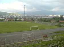
The largest sports venue in the city is the Lori Stadium with a capacity of 5,000 seats. It is mainly used for football matches. A renovation plan was scheduled in order to redevelop the stadium to meet the requirements of the UEFA.[6]
Other popular sports in the city include: handball, footsal and volleyball. The city is home to many sport schools for swimming, athletics, weightlifting, chess, gymnastics, table tennis and badminton.
The Academy of the Football Federation of Armenia in Vanadzor is currently under construction. It will be home to 1 natural grass and 2 artificial turf regular-sized pitches.
Notable people

- Stepan Zoryan, promeninet Armenian writer of the 20th century
- Suren Aghababyan, Soviet Armenian literary critic and Doctor of Philology
- Artavazd Peleshyan, director, film-maker
- Shavarsh Karapetyan, Soviet Armenian finswimmer
- Eduard Nalbandyan, current minister of foreign affairs
- Sergei Alifirenko, Olympic gold-medalist pistol shooter
- Tigran Sargsyan, current Prime Minister of Armenia
- Stepan Sarkisyan, freestyle wrestling Olympic silver-medalist
- Gor Mkhitarian, Armenian rock-musician and singer
- Vic Darchinyan, Armenian professional boxer, three-division world champion
- Roman Mitichyan, Armenian-American professional mixed martial artist, actor and stuntman
- Nareh Arghamanyan, Armenian pianist, winner of the 2008 Montreal International Musical Competition
International relations

Twin towns – Sister cities
Vanadzor is twinned with:
 Bagneux, France, since 1968[7]
 Pasadena, United States, since 1992
 Podolsk, Russia, since 2004[8]
 Batumi, Georgia, since 2006[9]
References
- ↑ Armstats:Population
- ↑ Hovhanessian, Richard G. (1997) The Armenian People from Ancient to Modern Times. New York. St. Martin's Press, 299
- ↑ Municipality of Vanadzor: Administrative area
- ↑ Parishes in the Region of Lori
- ↑ www.gov.am:Religious organizations in Armenia (in Armenian)
- ↑ FFA President’s cognitive visit to Vanadzor
- ↑ "Atlas français de la coopération décentralisée et des autres actions extérieures". Délégation pour l’Action Extérieure des Collectivités Territoriales (Ministère des Affaires étrangères) (in French). Retrieved 2013-08-22.
- ↑ "Podolsk sister cities". Translate.google.com. Retrieved 2010-04-29.
- ↑ "Batumi - Twin Towns & Sister Cities". Batumi City Hall. Archived from the original on 2012-05-04. Retrieved 2013-08-10.
- Vanadzor at GEOnet Names Server
- Report of the results of the 2001 Armenian Census, National Statistical Service of the Republic of Armenia
- World Gazeteer: Armenia – World-Gazetteer.com
External links
| Wikivoyage has a travel guide for Vanadzor. |
| Wikimedia Commons has media related to Vanadzor. |