Van der Grinten projection
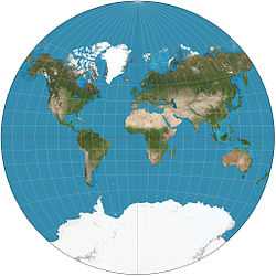
The van der Grinten projection is a compromise map projection that is neither equal-area nor conformal. It projects the entire Earth into a circle, though the polar regions are subject to extreme distortion. The projection was the first of four proposed by Alphons J. van der Grinten in 1904, and, unlike most projections, is an arbitrary geometric construction on the plane. It was made famous when the National Geographic Society adopted it as their reference map of the world from 1922 until 1988.[1]
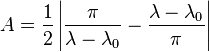
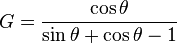
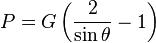
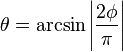
The geometric construction given by van der Grinten can be written algebraically:[2]
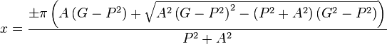
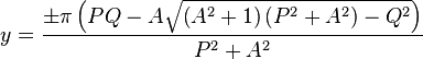
where  takes the sign of
  ,
,  takes the sign of
  and
and

Should it occur that  , then


Similarly, if  or
or  , then


In all cases, is the latitude,  is the longitude, and
  is the central meridian of the projection.
See also
References
- ↑ Flattening the Earth: Two Thousand Years of Map Projections, John P. Snyder, 1993, pp.258-262, ISBN 0-226-76747-7.
- ↑ Map Projections - A Working Manual, USGS Professional Paper 1395, John P. Snyder, 1987, pp.239-242