Vale, Guernsey
| Vale | |
|---|---|
| Parish | |
.gif) Location of Vale in Guernsey | |
| Crown Dependency | Guernsey, Channel Islands |
| Government | |
| • Electoral district | Vale |
| Area | |
| • Total | 8.8 km2 (3.4 sq mi) |
| Population | |
| • Total | 9,573 |
| • Density | 1,100/km2 (2,800/sq mi) |
| Time zone | GMT |
| • Summer (DST) | UTC+01 (UTC) |
Vale (Guernésiais: Lé Vale; French: Le Valle) is one of the ten parishes of Guernsey.
Until 1806 the parish occupied territory on the mainland of Guernsey, the Vingtaine de l'Epine, as well as the whole of Le Clos du Valle, a tidal island forming the northern extremity of Guernsey separated from the mainland by Le Braye du Valle, a tidal channel.
Le Braye du Valle was drained and reclaimed in 1806 by the British Government as a defence measure. Vale now consists of two non-contiguous territories.
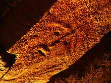 Le Gardien of Le Dolmen de Déhus |
Among features of the parish are:
- Vale Parish Church, St Michel du Valle
- L'Ancresse Common
- Le Dolmen de Déhus, which incorporates a megalithic art carving known as Le Gardien
- La Varde passage grave, the largest dolmen on the island.
- Vale Castle (which hosts the annual music festival 'Vale Earth Fair')
- Bordeaux Harbour
- The Vale Mill (the parishes most prominent landmark)
- Fort le Marchant shooting range
The parish was twinned with the Normandy port of Barneville-Carteret in 1987.
Coordinates: 49°29′34″N 2°31′22″W / 49.49278°N 2.52278°W
Vale is the north of Guernsey and has the maximum height of 30m