Val d'Aran
| Val d'Aran | |||
|---|---|---|---|
| Comarca | |||
| |||
|
Anthem: Montanhes araneses (Occitan) "Aranese mountains" | |||
 Location of Val d'Aran in Catalonia | |||
| Country |
| ||
| Autonomous community |
| ||
| Province | Lleida | ||
| Capital | Vielha e Mijaran | ||
| Municipalities | |||
| Government | |||
| • Body | Conselh Generau d'Aran | ||
| • Síndic | Carlos Barrera (CDA) | ||
| Area | |||
| • Total | 620.5 km2 (239.6 sq mi) | ||
| Population (1996) | |||
| • Total | 7,130 | ||
| • Density | 11/km2 (30/sq mi) | ||
| Demonym |
English: Aranese Occitan: aranés (m), aranesa (f) | ||
| Time zone | CET (UTC+1) | ||
| • Summer (DST) | CEST (UTC+2) | ||
| Official languages |
Aranese (Occitan), Catalan, Spanish | ||
| Website | Conselh Generau d'Aran | ||

The Val d'Aran (Occitan pronunciation: [ˈbal daˈɾan]; Catalan: Vall d'Aran [ˈbaʎ dəˈɾan]; Spanish: Valle de Arán [ˈbaʎe ðe aˈɾan]),[1] sometimes referred to as the Aran Valley in English,[2] is a valley, 620.47 square kilometres (239.56 sq mi) in area, in the Pyrenees mountains and a comarca (county) in the northwestern part of the province of Lleida, in Catalonia, northern Spain. Most of the valley constitutes one of only two areas of Spain,[3] and the only part of Catalonia, located on the northern side of the Pyrenees. Hence, this valley holds the only Catalonian rivers to flow into the Atlantic Ocean; for the same reason, the region is characterized by an Atlantic climate, instead of a Mediterranean one. As of 2001, most people in the Val d'Aran spoke Spanish (38.78%) as their native language, followed by Aranese (34.19%), then Catalan (19.45%) with 7.56% having a different native language.[4] Speakers of languages other than the local Aranese are typically people born outside the valley, or their children.[5]
The Val d'Aran borders France on the north, the Spanish Autonomous Community of Aragon to the west and the Catalan comarques of Alta Ribagorça to the south and Pallars Sobirà to the east. The capital of the comarca is Vielha, with 3,692 inhabitants (1996). The entire population of the valley is about 7,130 (1996). The Garonne river passes through the Val d'Aran after rising on the Saburedo Cirque and receiving the water of the Joèu river (from the slopes of nearby Aneto mountain and passing underground at the Forau de Aigualluts). It then reappears in the Val dera Artiga as a resurgence and flows into the Val d'Aran which is one of the highest valleys of the Pyrenees. The Noguera Pallaresa, with its head only a hundred meters from that of the Garona, flows the other way, toward the Mediterranean.
Before the construction of the Vielha tunnel, opened in 1948, the Val d'Aran had no direct communication with the south side of the mountains during winter. On October 3, 1949, Spanish Communist Party guerrillas trying to bring about the fall of the Spanish dictatorship entered the valley and took control of several villages until October 27, 1949.
Name and local language
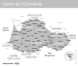
Aranese is the standardized form of the Gascon variety of the Occitan language. The name Val d'Aran is Aranese. "Val d'Aran" itself can be considered a pleonasm, as it would mean Valley of the Valley if one took into account its etymology (val in Gascon and aran from Basque haran), a combination that reflects its unique geography. Aranese has been regularly taught at school since 1984. Like several other minority languages in Europe that recently faced decline, Aranese is experiencing a renaissance.
Maps and road signs in Spain use the name "era Val d'Aran" to refer to the valley, where era is the Aranese singular feminine article as a part of the name. The same practice goes for all towns and other locations in Aran, for example, the Aranese spelling Vielha is used instead of Catalan and Spanish Viella to refer to the capital of Val d'Aran.
Basque toponyms show that Basque was spoken further along the Pyrenees than today. An example is Val d'Aran since haran itself is the Basque word for "valley". However, the growing influence of Latin began to drive Basque out, with Basque still being spoken at the turn of the first millennium.[6]
Government and economy
The area is divided in six administrative divisions, called terçons (meaning "thirds", as the divisions were formerly three in number). The current arrangement of the divisions dates from the 15th century. Since 1991, Val d'Aran has an autonomous government, called Conselh Generau ("General Council" in Occitan).
Major political powers are Unity of Aran - Aranese Nationalist Party (Socialists' Party of Catalonia local section, the governing party) and Aranese Democratic Convergence (Democratic Convergence of Catalonia local section). Occitan Republican Left was founded in 2008.
The main income is from ski resorts in winter, and from tourism in summer. In 2012, Val d'Aran launches the first edition of Dig@ran European Festival on digital arts from June 29 to July 8.
Other primary sectors of the economy include forest products, cattle raising and apiculture, all of which have become less and less important since the opening of ski resorts.
Municipalities
These population figures are from January 1, 2006 (source: Spanish INE).
| Location | Population |
|---|---|
| Arres | 61 |
| Bausen | 52 |
| Bossòst | 1,043 |
| Es Bòrdes | 247 |
| Canejan | 104 |
| Les | 903 |
| Naut Aran | 1,732 |
| Vielha e Mijaran | 5,239 |
| Vilamòs | 173 |
Fauna

Many native animals of Val d'Aran are in peril of extinction. There are programs of reintroduction and/or protection for:
- Brown Bear (Ursus arctos)
- Rock ptarmigan (Lagopus mutus)
- Aran rock lizard (Lacerta aranica)
- Bearded vulture (Gypaetus barbatus)
References
- ↑ The name is preceded by the articles era (Occitan, feminine), la (Catalan, feminine), el (Spanish, masculine).
- ↑ http://www.thinkspain.com/news-spain/15687/aran-valley-attack-bear-may-be-pregnant
- ↑ Luzaide/Valcarlos, in Navarra, is also on the northern side of the Pyrenees.
- ↑ "Cens lingüístic de l'aranès de 2001" (PDF). Retrieved 2012-08-06.
- ↑ Cens lingüístic de l'aranès de 2001 (section 10: Llengua materna de la població de la Val d'Aran. Distribució per lloc de naixement. 2001) (in Catalan)
- ↑ Morvan, Michel (1997). Les Origines linguistiques du basque. Bordeaux: Presses Universitaires de Bordeaux (PUB). p. 26. ISBN 978-2-86781-182-1.
- Instituto Nacional de Estadística (in Spanish). Reference for populations of municipalities as of January 1, 2005.
- IDESCAT: Statistics for Val d'Aran (in Catalan), source for surface area, list of municipalities.
- Smith, Dominic. "Language planning in the Val d’Aran: The recent work of the Conselh Generau d’Aran’s ‘Oficina de Foment e Ensenhament der Aranés’ and its effects on the Aranés-speaking population." (PDF). 2003.
External links
- Page of the Conselh Generau d'Aran (Occitan)
- Information from the Generalitat de Catalunya (Catalan)
- Dig@ran European Festival on digital arts (Vielha, Catalonia)
- Wiki of the Company of Skiers and Climbers of Viella Veterans Association (Spanish)
| ||||||||||
| ||||||||