Val Camonica


.jpg)
.JPG)
.jpg)
.jpg)
.jpg)
.jpg)

.jpg)
Val Camonica (also Valcamonica or Camonica Valley, in camunian dialect Al Camònega, poetic Camunia) is one of the largest valleys of the central Alps, in eastern Lombardy, about 90 km long. It extends from the Tonale Pass, at 1883 metres above sea level, to Corna Trentapassi, in the comune of Pisogne, near Lake Iseo. It has an area of about 1,335 km2[1] and 118,323 inhabitants.[2]
The River Oglio runs through its full length, rising at Ponte di Legno and flowing into Lake Iseo between Pisogne and Costa Volpino.
Almost all of the valley is included in the administrative territory of the province of Brescia, except for Lovere, Rogno, Costa Volpino and the Val di Scalve, which belong to the province of Bergamo.
Etymology
Valle Camonica derives its name from the Latin Vallis Camunnorum, meaning "the Valley of the Camunni", the name by which the Romans called the inhabitants (today known as Camuni).
Geography
Territory
Valle Camonica can be divided into three main areas:
- Lower Val Camonica: a flat area of meadows and fields, which starts from the shores of Lake Iseo and reaches up to the transverse ridge of Bienno, sometimes referred to as the Breno Threshold;
- Middle Val Camonica: this extends from the Breno Threshold to the municipality of Sonico - Edolo. The lower middle valley extends from Breno to Sellero, and the upper middle valley from the narrow gorge at Cedegolo to Sonico - Edolo;
- High Val Camonica: This part of the valley follows the Periadriatic Seam, and is oriented from east to west. Starting in the Val di Corteno, it continues as far as the town of Ponte di Legno at its head. Its climate is similar to that of central Valtellina.
It is bounded by these borders:
| North | East | South | West |
|
|
|
- The Val di Scalve is a side valley of Val Camonica, but has always been a separate entity both historically and administratively.
Hydrography
The Valle Camonica is traversed by the River Oglio (Oi in camunian dialect), the fifth longest river in Italy, which rises at Ponte di Legno from the confluence of the Frigidolfo and Narcanello rivers. It flows into Lake Iseo between the municipalities of Pisogne and Costa Volpino.
Numerous streams, some of them seasonal and thus dry during the summer, descend from the mountainsides and flow into the Oglio.
At high altitude there are many alpine lakes, including Lago Moro, as well as many artificial reservoirs, such as the Lago d'Arno, constructed in the first half of the twentieth century to feed the area's hydroelectric plants.
History
The Valle Camonica probably became habitable only around 15,000 years ago, at the end of last Ice Age, with the melting of the glacier that carved out the valley. It is likely that the first humans visited the valley in epipaleolithic times, and appear to have settled by the Neolithic period. When the Ancient Romans extended their dominions north of the River Po, they encountered a people called the Camunnni, of unknown origin, populating the valley. Rock Drawings in Valcamonica About 300,000 petroglyphs survive from this period. By the end of the first century BC, the Valle Camonica was ruled by Ancient Rome, which established the city of Cividate Camuno, with baths, an amphitheater and a large temple dedicated to Minerva.
During the Middle Ages, numerous clashes between the Guelphs and Ghibellines took place in this region. The Guelphs supported the power of the Bishop of Brescia and the papacy, while the Ghibellines sided with the Holy Roman Emperor. In 1287 the Camonica Valley rebelled against control by Brescia and sided with the Visconti, lords of Milan, who extended their control over the area during the 14th century. From 1427 to 1454 there were numerous battles between the Republic of Venice and Milan for the control of the valley. Ultimately the Valley came under the control of the Venice. During the following centuries, the civilian population grew and engaged in the iron trade.
Valcamonica, the most extensive of the Lombard valleys and no less renowned for its ancient military history, for its most honourable noble families, and men who were distinguished in letters, in arms, and public offices, and famed for the fertility of its soil; for the industry and commerce of its people….—Agostino Caggioli - Storia di Valcamonica, 1853
After the conquest of Venice by Napoleon in 1797, it was separated from Venice. After the deposition of Napoleon, the area was controlled by the Austro-Hungarian Empire. In 1859, Val Camonica was annexed to the Kingdom of Italy. During World War I battle lines stretched along the eastern border of Val Camonica, across the Adamello Group. The battles fought in this area are known as the White War in the Adamello.
In 1955, the National Park of Naquane stone carvings at Capo di Ponte was created by the Archaeological Administration of Lombardy.
Monuments and places of interest
UNESCO Site
It is home to the greatest complex of rock drawings in Europe, with approximately 300,000 petroglyphs,[3] dated from epipaleolithic to the middle ages.
- Parco nazionale delle incisioni rupestri di Naquane in Capo di Ponte
- Parco archeologico nazionale dei massi di Cemmo
- Parco archeologico comunale di Seradina-Bedolina in Capo di Ponte
- Parco archeologico di Asinino-Anvòia in Ossimo
- Parco archeologico comunale di Luine in Darfo Boario Terme
- Parco archeologico comunale di Sellero
- Parco archeologico comunale di Sonico
- Riserva naturale Incisioni rupestri di Ceto, Cimbergo e Paspardo in Nadro
Medieval villages
- Bienno, recognised as one of the Most Beautiful Villages of Italy
- Lovere, also recognised as one of the Most Beautiful Villages of Italy
- Pescarzo (Capo di Ponte), a characteristic small town.
Castles
- Castle of Breno, the largest castle of Val Camonica
- Castle of Gorzone, home of the Federici family, standing on a small hill next to the Dezzo torrent
- Castle of Cimbergo, located in the valley of the Re, dominates the middle Valley
- Castle of Lozio, the fortress where the Lozio Massacre took place
- Castle of Mù, the Federici bastion in the upper valley, of which only the foundations remain
Roman city
- Theatre and Anphitheater at Cividate Camuno
- Temple of Minerva at Breno
Mountain excursions
- CAI paths in the Parco dell'Adamello
- First World War (so-called Guerra Bianca in Adamello) Trench at Vezza d'Oglio
Roman Baths
- Boario Terme
- Angolo Terme
Museums and theme parks
- Parco tematico Archeopark, Darfo Boario Terme
- Museo etnografico del ferro, delle arti e tradizioni popolari, Bienno
- Museo Civico Camuno, Breno
- Museo didattico di arte e vita preistorica, Capo di Ponte
- Museo didattico della riserva, Nadro
- Museo archeologico di Valle Camonica, Cividate Camuno
- Mostra museo Camillo Golgi, Corteno Golgi
- Museo etnografico, Ossimo
- Museo parrocchiale d'arte sacra, Ponte di Legno
- Museo della Guerra Bianca in Adamello, Temù
Notable sanctuaries and churches
- Chiesa di Santa Maria della Neve in Pisogne
- Chiesa di Sant'Antonio in Breno
- Chiesa di Santa Maria Annunziata in Bienno
- Santuario del Cristo Re in Bienno
- Chiesa di Santa Maria Assunta in Esine
- Monastero di San Salvatore in Capo di Ponte
- Oratorio dei Disciplini in Montecchio
- Pieve di San Siro in Cemmo
- Santuario della Via Crucis in Cerveno (Sacri Monti)
Winter sports
Winter sports Centers at Ponte di Legno, Borno, Montecampione, Aprica and Val Palot
Photo gallery
-
.jpg)
Concarena
-

Valle Adamé
-
.jpg)
Pizzo Badile Camuno
-

Valle Camonica from Breno to north
-

Valle Camonica from Braone to south
-

Valle Camonica from Gorzone
-
.jpg)
Petroglyph from Foppe of Nadro
-
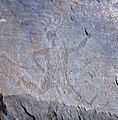
Running Priest in Capo di Ponte
See also
References
- ↑ Area of the municipalities, excluding Val di Scalve
- ↑ Sum of ISTAT data of communes at 31 December 2007
- ↑ "Introduzione all'arte rupestre della Valcamonica su Archeocamuni.it" (in Italian). Retrieved 11 May 2009.
External links
| Wikimedia Commons has media related to Val Camonica. |
- Itinera in Valcamonica (EN)
- Italian World Heritage Sites
- National museum and archaeological park with Roman theatre and amphitheatre
- Valcamonica Rock Art, records and pictures
- EuroPreArt, European Prehistoric Art database, 50 Valcamonica rock art records
| ||||||||||||||||||||||||
| |||||||||||||||||||||||||||||||||

Coordinates: 46°00′27″N 10°20′51″E / 46.00750°N 10.34750°E