Vaassen
| Vaassen | ||
|---|---|---|
| ||
| Coordinates: 52°17′17″N 5°58′10″E / 52.28806°N 5.96944°E | ||
| Country | Netherlands | |
| Province | Gelderland | |
| Municipality | Epe | |
| Population (01-11-2011) | 15.791 | |

Vaassen (Dutch pronunciation: [ˈvaːsə(n)]) (Low German: Vaossen) is one of four villages in the Dutch municipality Epe. Vaassen is situated between Apeldoorn and Zwolle, on the eastern edge of the Veluwe in the province of Gelderland and has 12,719 inhabitants (2008). Vaassen was an independent municipality up to 1 January 1818, when it merged with Epe.[1]
History
The town is mentioned for the first time in a certificate from the Codex Laureshamnensis of the monastery of Lorschin the year 891 or 892, when someone called "Brunhilde" gave a farmhouse and the church to Lorsch.[2] The name Vaassen derives from "Fasna", an old word for a specific rough type of grass.[3]
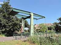
From the 2nd of September 1887 up to the 8th of October 1950 there was a railwaystation in Vaassen. The station was part of the so-called Baronline between Apeldoorn and Zwolle. In 1950 the station was closed because the line was discontinued. The former railway station is still in its original place, but now used as a dwelling.
Vaassen is characterized by a centuries-long coexistence of Protestant and Roman Catholic populations.
Architecture
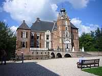
Vaassen's most remarkable historical building is the 16th century Cannenburgh Castle, once home to the knight Maarten van Rossum.
Neighborhoods in Vaassen
Berkenoord, Berkenoord II, The Oosterhof, Heggerenk, Oranjebuurt, Transvaalbuurt, Vogelbuurt, Industriewijk, Vulcanusbuurt and Vossenhoek.
Townships of Vaassen
De Hegge, De Jonas, Geerstraat, Hafkamp, Kortenbroek, 't Laar, Niersen, Vaassense Broek and De Uulenberg.
Sightseeing
- Daams' Mill. An in 1990 restored 8-square wind mill with a corn mill function. To ensure the windage of the mill, but also the development of the center of Vaassen, by mid-2012 the mill was raised with 4.9 meters. The raising needed to be done because of the so-called wind rights.
References
External links
- J. Kuyper, Gemeente Atlas van Nederland, 1865-1870, "Vaassen". Map of the former municipality, around 1868.
- Site of the town of Vaassen
- Municipality Epe
- Historical association Ampt Epe
- Museum Vaassen History
- Soccer club SV Vaassen
- Cavente Children's Village
- Broken Wings Vaaassen
- Friends of the Daams' Mill Association (in Dutch)
| ||||||||||||||||||