Vézère
| Vézère | |
|---|---|
 | |
| Origin | Plateau de Millevaches |
| Mouth |
Dordogne 44°52′53″N 0°53′26″E / 44.88139°N 0.89056°ECoordinates: 44°52′53″N 0°53′26″E / 44.88139°N 0.89056°E |
| Basin countries | France |
| Length | 211 km |
| Source elevation | 970 m |
| Avg. discharge | 50 m³/s |
| Basin area | 3,708 km² |
| Prehistoric Sites and Decorated Caves of the Vézère Valley | |
|---|---|
| Name as inscribed on the World Heritage List | |
| Type | Cultural |
| Criteria | i, iii |
| Reference | 85 |
| UNESCO region | Europe and North America |
| Inscription history | |
| Inscription | 1979 (3rd Session) |
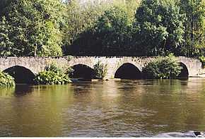
The Vézère (Occitan: Vesera) is a 211 km long river in southwestern France. It is an important tributary to the Dordogne River. Its source is in the northwestern part of the elevated plateau known as the Massif Central. It flows southwest through the following départements and cities:
- Corrèze: Pérols-sur-Vézère, Bugeat, Uzerche, Vigeois, Brive-la-Gaillarde
- Dordogne: Montignac, Terrasson-Lavilledieu, Les Eyzies-de-Tayac-Sireuil, Le Bugue
It flows into the Dordogne near Le Bugue. A tributary of the Vézère is the Corrèze River.
The Vézère Valley is famed for its prehistoric cave systems, containing numerous cave paintings and hominid remains. UNESCO collectively designated these a World Heritage Site in 1979. Among the sites with remarkable caves is Lascaux.
References
External links
![]() Media related to Vézère at Wikimedia Commons
Media related to Vézère at Wikimedia Commons