Väätsa Parish
| Väätsa Parish Väätsa vald | |||
|---|---|---|---|
| Municipality of Estonia | |||
| |||
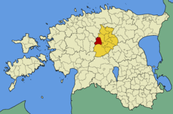
 Väätsa Parish within Järva County. | |||
| Country |
| ||
| County |
| ||
| Administrative centre | Väätsa | ||
| Area | |||
| • Total | 195.33 km2 (75.42 sq mi) | ||
| Population (01.01.2004) | |||
| • Total | 1,479 | ||
| • Density | 7.6/km2 (20/sq mi) | ||
| Website | www.vaatsa.ee | ||
Väätsa Parish (Estonian: Väätsa vald) is a rural municipality in central Estonia. It is a part of Järva County. The municipality has a population of 1,479 (as of 1 January 2004) and covers an area of 195.33 km². The population density is 7.6 inhabitants per km².
Administrative centre of the municipality is Väätsa small borough. There are also 10 villages in Väätsa Parish: Aasuvälja, Lõõla, Piiumetsa, Reopalu, Roovere, Röa, Saueaugu, Vissuvere, Väljataguse, Ülejõe.
Geography
The landscape at Väätsa is an area with large cultivated fields and neat woodland in the northern part of the Türi drumlins and in the upper courses of the Lokuta and Reopalu rivers. In the borough of Väätsa, the manor complex and park dating from the early 19th century, the historic commune house from the late 19th century and the skillfully integrated buildings from the collective farm period will attract your attention. In 1970, an extension was attached to the single-storey classicistic main building of the Väätsa manor. The manor’s stable has been reconstructed as a guesthouse. The irregularly shaped manor complex is integrated with a park with a moderate range of species, a pond in the southern part and a boundary wall around it. Immediately to the south, west and north of the manor you can see modern buildings. An artificial lake created on the Lokuta River helps make Väätsa borough more impressive. The lake has a varied shoreline and fine detached houses on the western and eastern shores. From the Männimäe drumlin on the eastern shore you can enjoy a beautiful view of the lake and the buildings around it.
External links
- Official website (Estonian)
Coordinates: 58°53′N 25°27′E / 58.883°N 25.450°E
| ||||||||||||

