Uzh River
Coordinates: 48°35′54″N 21°59′26″E / 48.5983°N 21.9906°E
| Uzh River | |
|---|---|
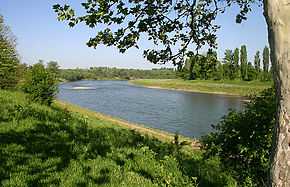 Uzh River near Uzhhorod | |
| Origin | Ukraine |
| Mouth | Laborec |
| Basin countries | Ukraine, Slovakia |
| Length | 127 km (79 mi) |
| Source elevation | |
| Avg. discharge | |
| Basin area | 2750 km² |
The Uzh (Ukrainian: Уж; translit. Uzh; Slovak: Uh; Hungarian: Ung, Polish: Uż) is a river in Ukraine and Slovakia. Its name comes from the ancient west Slavic dialect word už, meaning "Snake", (lat. "Serpentes").
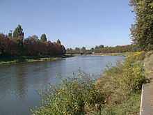
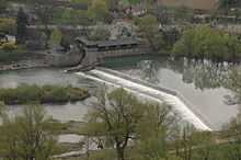
The Uzh River is a tributary of the Laborets River, a river that flows in the Tysa Lowland in Transcarpathia oblast of western Ukraine. The river feeds numerous industries and is a source of drinking water and irrigation as well. It also has a hydropower station on it. Several important cities lie along its course, including Uzhhorod.[1]
It is 127 km (79 mi) long, of which 21.3 km (13.2 mi) are in Slovakia. It flows into the Laborec river near the city of Drahňov in the Michalovce District (okres).
The Ukrainian city of Uzhhorod and the semi-ruined Nevitske Castle are situated by the Uzh. The river forms part of the Slovakia–Ukraine border for about 1.5 km (0.93 mi) near the village of Pinkovce.

References
- ↑ "Uzh River". Canadian Institute of Ukrainian Studies. Retrieved 11 September 2013.
| Wikimedia Commons has media related to Uzh River. |