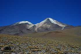
Uturunku
For the mountain in Peru, see Uturunku (Peru).
| Uturunku | |
|---|---|
 | |
| Elevation | 6,008 m (19,711 ft)[1] |
| Location | |
| Location | Bolivia |
| Coordinates | 22°16′S 67°11′W / 22.27°S 67.18°W |
| Geology | |
| Type | Stratovolcano |
| Last eruption | Pleistocene |
Uturunku (Quechua for "jaguar",[2][3] hispanicized spellings Uturunco, Uturuncu), the highest summit in southwestern Bolivia, is a stratovolcano in the Potosí Department, Sur Lípez Province, San Pablo de Lípez Municipality. The volcano produced lava between 890,000 and 271,000 years ago, with younger lavas found at higher altitudes.[4] There are clusters of active fumarole near the summit.[5]
Researchers have determined that a large, roughly circular "disc" of land surrounding the volcano, approximately 70 km across, has been rising at 1 to 2 cm per year since at least the early 1990s, making it "one of the fastest uplifting volcanic areas on the Earth", according to volcanologist Shan de Silva.[6] [7]
See also
Footnotes
- ↑ 2003 Fall Meeting of American Geophysical Union
- ↑ Diccionario Quechua - Español - Quechua, Academía Mayor de la Lengua Quechua, Gobierno Regional Cusco, Cusco 2005 (Quechua-Spanish dictionary)
- ↑ Teofilo Laime Ajacopa, Diccionario Bilingüe Iskay simipi yuyayk'ancha, La Paz, 2007 (Quechua-Spanish dictionary)
- ↑ American Journal of Science
- ↑ Global Volcanism Program
- ↑ Andrea Mustain (24 October 2011). "Rapidly Inflating Volcano Creates Growing Mystery". LiveScience.com.
- ↑ "Bolivian 'supervolcano' could alter global climate". Greenwire. 14 February 2012.