Utah State Route 55
| ||||
|---|---|---|---|---|
| U.S. Route 6 Business | ||||
| Route information | ||||
| Defined by Utah Code §72-4-111 | ||||
| Maintained by UDOT | ||||
| Length: | 2.942 mi[1] (4.735 km) | |||
| Existed: | 1975 – present | |||
| Major junctions | ||||
| West end: |
| |||
|
| ||||
| East end: |
| |||
| Highway system | ||||
| ||||

State Route 55 is a short highway that loops around the town of Price in central Utah, beginning and ending at US-6/US-191 in a span of three miles (5 km). US-6 Business is cosigned with the route.
Route description
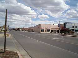
From its western terminus at the offramp of US-6/US-191, the highway goes east on 100 North. At its junction 300 East, it turns south briefly before returning east on Main Street. It continues on Main Street, which veers to the south until meeting again with another grade-separated intersection.
History
Previous route
When SR-55 was first formed in 1927, it ran from SR-14 to the south boundary of Cedar Breaks National Monument. It maintained this designation until its subsequent deletion in 1969.[2]
Current route
In 1975 the route was formed again, this time forming a partial loop around SR-27, now US-6/US-191. Since then, the route has not been changed.[2]
Major intersections
The entire route is in Price, Carbon County. [3]
| mi[1] | km | Destinations | Notes | ||
|---|---|---|---|---|---|
| 0.000– 0.059 | 0.000– 0.095 | Western terminus; Grade-separated intersection | |||
| 0.913 | 1.469 | ||||
| 2.942 | 4.735 | Eastern terminus | |||
| 1.000 mi = 1.609 km; 1.000 km = 0.621 mi | |||||