Ushishir
| Native name: <span class="nickname" ">Ушишир 宇志知島 | |
|---|---|
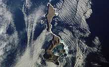
 NASA picture of Ushishir Island | |
|
| |
| Geography | |
| Location | Sea of Okhotsk |
| Coordinates | 47°31′N 152°48′E / 47.52°N 152.80°E |
| Archipelago | Kuril Islands |
| Area | 5 km2 (1.9 sq mi) |
| Highest elevation | 401 m (1,316 ft) |
| Highest point | Mikasayama |
| Country | |
|
Russia | |
| Demographics | |
| Population | 0 |
| Ethnic groups | Ainu (formerly) |

Ushishir (Russian: Ушишир; Japanese 宇志知島; Ushishiru-tō) is an uninhabited volcanic island located in the centre of the Kuril Islands chain in the Sea of Okhotsk in the northwest Pacific Ocean. Its name is derived from the Ainu language for "hot spring".
Geology
Ushishir consists of two islets connected by a narrow spit of land with an area of 5 km² [1]
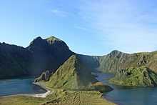
These islets are the tops of a partially submerged volcano. The southern island (Yankicha Russian: o.Янкича ) consists of the summit caldera and has a maximum width of 2.5 kilometers. The caldera has a diameter of 1.6 kilometers, and is breached on the south, forming a sea-water crater bay. The bay has an estimated depth of 30 meters, and there is strong evidence of ongoing underwater volcanic activity, as evidenced by frequent bubbles, altered water chemistry and the presence of bacteria mats. Two small lava domes for small islands in the central lagoon, and numerous fumaroles and hot springs are along the southeast caldera shoreline. The island’s highest point Mikasayama (御笠山) is 401 meters high, and is on the eastern shore. The northern islet (Ryponkicha Russian: o. Рыпонкча ) is the larger of the two, and consists of a portion of the volcano’s flank, with sheer cliffs rising 131 meters from the sea. Ushishir is still active volcano with a major eruption with the last known eruption in 1884.
History
Ushishir had no permanent habitation prior to European contact, but was visited in summer by the Ainu tribes from Rasshua, who regarded the island as a sacred land, which they identified as the home of the thunder god. Remains of Ainu huts have been found on the northern slopes of Yankicha’s crater bay. Claimed by the Empire of Russia, sovereignty over Ushishir was passed to the Empire of Japan per the Treaty of Saint Petersburg (1875) along with the rest of the Kuril Islands. Approaches to the island are difficult due to frequent fogs, rapid ocean currents and the presence of numerous small offshore rocks. The island was formerly administered as part of Shimushiro District of Nemuro Subprefecture of Hokkaidō. After World War II, the island came under the control of the Soviet Union, and is now administered as part of the Sakhalin Oblast of the Russian Federation.
See also
References
- "Ushishur". Global Volcanism Program. Smithsonian Institution.
- Oceandots entry at the Wayback Machine (archived December 23, 2010)
External links
| Wikimedia Commons has media related to Ushishir. |
Notes
- ↑ "International Kuril Island Project(IKIP)". University of Washington Fish Collection or the respective authors.
Further reading
- Gorshkov, G. S. Volcanism and the Upper Mantle Investigations in the Kurile Island Arc. Monographs in geoscience. New York: Plenum Press, 1970. ISBN 0-306-30407-4
- Krasheninnikov, Stepan Petrovich, and James Greive. The History of Kamtschatka and the Kurilski Islands, with the Countries Adjacent. Chicago: Quadrangle Books, 1963.
- Rees, David. The Soviet Seizure of the Kuriles. New York: Praeger, 1985. ISBN 0-03-002552-4
- Takahashi, Hideki, and Masahiro Ōhara. Biodiversity and Biogeography of the Kuril Islands and Sakhalin. Bulletin of the Hokkaido University Museum, no. 2-. Sapporo, Japan: Hokkaido University Museum, 2004.