Urup
| Native name: <span class="nickname" ">Уруп 得撫島 | |
|---|---|
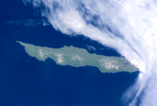 NASA picture of Urup Island | |
 | |
| Geography | |
| Location | Sea of Okhotsk |
| Coordinates | 45°56′N 150°02′E / 45.933°N 150.033°E |
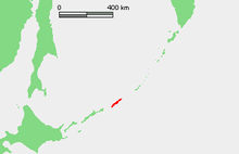
| Archipelago | Kuril Islands |
| Area | 1,430 km2 (550 sq mi) |
| Highest elevation | 1,426 m (4,678 ft) |
| Country | |
|
Russia | |
| Demographics | |
| Population | 0 (2010) |
| Ethnic groups | Ainu, Japanese (formerly) |

Urup (Russian: Уру́п, Japanese: 得撫島, Ainu: ウルㇷ゚, Urup) is an uninhabited volcanic island in the Kuril Islands chain in the south of the Sea of Okhotsk, northwest Pacific Ocean. Its name is derived from the Ainu language word for salmon trout.
Geography and climate
Urup has a roughly rectangular shape, measuring 120 kilometres (75 mi) along its long axis and approximately 20 kilometres (12 mi) along its narrow axis. It is the fourth largest of the Kuril Islands, with an area of 1430 km² The highest point is Gora Ivao (1,426 metres (4,678 ft)).
The strait between Urup and Iturup is known as the Vries Strait, after Dutch explorer Maarten Gerritsz Vries, the first recorded European to explore the area. The strait between Urup and Simushir is known as the Boussole Strait, after the French word for "compass", which was the name of one of La Pérouse's vessels. This French mariner explored the area of the Kuril Islands in 1787.
Urup consists of four major groups of active or dormant stratovolcanos:
- Kolokol Group (Japanese: 得撫富士), with a height of 1,328 metres (4,357 ft) has erupted as recently as 1973.
- Rudakov (Japanese: 台場山), with a height of 524 metres (1,719 ft) has a 700 meter wide, funnel-like crater containing a 300 meter wide lake
- Tri Sestry (Russian: Три сестры;Japanese: 硫黄山), with a height of 998 metres (3,274 ft) has flanks cut by deep ravines and has numerous hot springs.
- Gora Ivao (Japanese: 白妙山), with a height of 1,426 metres (4,678 ft) is the highest point on the island. The southeast-most cone bisects a glacial valley, forming a lake.
Despite its temperate latitude, the cold Oyashio Current and powerful Aleutian Low combine to give Urup a subarctic climate (Köppen Dfc) with mild, foggy summers and cold, snowy winters. In reality the climate resembles the subpolar oceanic climate of the Aleutian Islands much more than the hypercontinental climate of Siberia proper or Manchuria, but the February mean of −5.8 °C (21.6 °F) is well below the limit of “oceanic” climates. Urup, like all the Kuril islands, experiences extremely strong seasonal lag, with the highest temperatures in August and September, the lowest in February and temperatures typically in fact warmer at the autumn equinox than at the summer solstice.
| Climate data for Urup Island | |||||||||||||
|---|---|---|---|---|---|---|---|---|---|---|---|---|---|
| Month | Jan | Feb | Mar | Apr | May | Jun | Jul | Aug | Sep | Oct | Nov | Dec | Year |
| Record high °C (°F) | 3.9 (39) |
8.9 (48) |
5.0 (41) |
13.9 (57) |
21.1 (70) |
26.1 (79) |
23.9 (75) |
25.0 (77) |
22.2 (72) |
17.8 (64) |
13.9 (57) |
10.0 (50) |
26.1 (79) |
| Average high °C (°F) | −2.8 (27) |
−3.9 (25) |
−1.7 (28.9) |
2.8 (37) |
6.1 (43) |
8.9 (48) |
12.2 (54) |
13.9 (57) |
13.3 (55.9) |
9.4 (48.9) |
3.9 (39) |
0.0 (32) |
5.2 (41.4) |
| Average low °C (°F) | −6.7 (19.9) |
−7.8 (18) |
−5.6 (21.9) |
−2.2 (28) |
0.6 (33.1) |
2.8 (37) |
5.6 (42.1) |
7.8 (46) |
7.2 (45) |
4.4 (39.9) |
0.0 (32) |
−3.9 (25) |
0.2 (32.4) |
| Record low °C (°F) | −16.1 (3) |
−16.1 (3) |
−17.8 (0) |
−8.9 (16) |
−3.9 (25) |
−2.8 (27) |
0.0 (32) |
2.8 (37) |
0.0 (32) |
−2.2 (28) |
−7.2 (19) |
−12.2 (10) |
−17.8 (0) |
| Average precipitation mm (inches) | 116.6 (4.591) |
76.5 (3.012) |
93.0 (3.661) |
97.0 (3.819) |
93.5 (3.681) |
71.6 (2.819) |
117.9 (4.642) |
103.6 (4.079) |
154.9 (6.098) |
158.5 (6.24) |
139.2 (5.48) |
149.1 (5.87) |
1,371.4 (53.992) |
| Source: Worldwide Bioclimatic Classification System[1] | |||||||||||||
History
Urup was originally inhabited by the Ainu, the native peoples of the Kurils, Sakhalin and Hokkaidō. The first recorded visit by Europeans was in 1643, when a ship of the Dutch East India Company commanded by Maarten Gerritsz Vries landed, probably seeking furs.[2] It appears on an official map showing the territories of Matsumae Domain, a feudal domain of Edo period Japan dated 1644, and these holdings were officially confirmed by the Tokugawa shogunate in 1715. Administration of the island came under the Matsumae domain’s regional office location on Kunashir from 1756.
Russian fur traders appeared in the late 18th century, hunting sea otter and seizing foreign ships in the area. There were clashes between the Russians and the Ainu in 1772, and the Russians left for a time, but soon returned. G.F. Muller’s Voyages & Découvertes faites par les Russes (Amsterdam, 1766) contained a list and description of the Kuril Islands, including Urup whose people were said to trade with the Japanese but were not under their control. A small Russian presence was established on Urup by the fur trader Ivan Chernyi in 1768, acting on instructions from the governor of Siberia. During the 1770s it was the base for attempts to establish trade with the Japanese on Yezo (Hokkaido) which came to an end when it was destroyed by a tsunami in June 1780.[3]
During the decade following 1795, a party of 40 Russian men and women under Zvezdochetov established on Urup a colony baptized "Slavorossiia".[4] In 1801, the Japanese government officially claimed control of the island, incorporating it into Ezo Province (now Hokkaidō Prefecture). This led to a series of clashes with Imperial Russia over Urup and the other Kurils, and sovereignty initially passed to Russia under the terms of the Treaty of Shimoda in 1855. The same year, in an effort to find the Russian fleet in the Pacific Ocean during the Crimean War, a French-British naval force reached the port of Hakodate (open to British ships as a result of the Anglo-Japanese Friendship Treaty of 1854), and sailing further north, landed on Urup, taking official possession of the island as "l'Isle de l'Alliance" and nominating a local Aleut inhabitant as provisional governor. The Treaty of Paris (1856) restituted the island to Russian control.[5]
Under the Treaty of Saint Petersburg (1875), sovereignty passed to the Empire of Japan along with the rest of the Kuril islands. The island was formerly administered as part of Uruppu District of Nemuro Subprefecture of Hokkaidō. The remaining Ainu inhabitants were relocated to Shikotan, and replaced by Japanese colonists.
During World War II, all civilian inhabitants of the island were relocated to the Japanese home islands, and towards the end of the war, the Imperial Japanese Army stationed approximately 6000 troops on Uruppu, including the IJA 129th Independent Mixed Brigade, 5th Independent Tank Company, 23rd Independent AA Company, 80th Airfield Battalion and 6th Disembarkation Unit. During the Invasion of the Kuril Islands by the Soviet Union after the end of World War II, Japanese forces on Uruppu surrendered without resistance.
In 1952, upon signing the Treaty of San Francisco, Japan renounced its claim to the island.[6] Soviet Border Troops occupied the former Japanese military facilities until they were withdrawn upon the dissolution of the Soviet Union in 1991. The island is now uninhabited and is administered as part of the Sakhalin Oblast of the Russian Federation.
See also
References
- ↑ RUSSIA - OSTROV YRUPP KUR, accessed 29 November 2011
- ↑ THE 17TH AND 18TH CENTURIES
- ↑ George A. Lensen, The Russian Push toward Japan:Russo-Japanese relations, 1697–1875, Princeton University Press, 1959, pp. 61–85; Valery O. Shubin, ‘Russian Settlements in the Kuril Islands in the 18th and 19th centuries’, Russia in North America: Proceedings of the 2nd International Conference on Russian America, Kingston & Fairbanks, Limestone Press,1990, pp. 425–450.
- ↑ John J. Stephan, The Kuril Islands, Oxford, Clarendon Press, 1974, pp. 64.
- ↑ Thierry Mormanne : "La prise de possession de l'île d'Urup par la flotte anglo-française en 1855", Revue Cipango, "Cahiers d'études japonaises", No 11 hiver 2004 pp. 209–236.
- ↑ History of the Kuril Islands
Further reading
- Gorshkov, G. S. Volcanism and the Upper Mantle Investigations in the Kurile Island Arc. Monographs in geoscience. New York: Plenum Press, 1970. ISBN 0-306-30407-4
- Krasheninnikov, Stepan Petrovich, and James Greive. The History of Kamtschatka and the Kurilski Islands, with the Countries Adjacent. Chicago: Quadrangle Books, 1963.
- Rees, David. The Soviet Seizure of the Kuriles. New York: Praeger, 1985. ISBN 0-03-002552-4
- Stephan, John J., The Kuril Islands, Oxford, Clarendon Press, 1974.
- Takahashi, Hideki, and Masahiro Ōhara. Biodiversity and Biogeography of the Kuril Islands and Sakhalin. Bulletin of the Hokkaido University Museum, no. 2-. Sapporo, Japan: Hokkaido University Museum, 2004.
- Location
- Geographic data
- Picture