Urkulu
| Urkulu | |
|---|---|
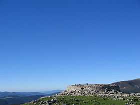 Remains of the Roman tower on Urkulu's summit | |
| Elevation | 1,419 m (4,656 ft) |
| Pronunciation | Basque: [uɾˈkulu] |
| Location | |
 Urkulu Location in Spain | |
| Location | Spain, France |
| Range | Pyrenees |
| Coordinates | 43°2′44.52″N 01°14′28.6″W / 43.0457000°N 1.241278°WCoordinates: 43°2′44.52″N 01°14′28.6″W / 43.0457000°N 1.241278°W |
| Climbing | |
| Easiest route | From Organbidexka |
Urkulu is an iconic mountain in the Basque Country straddling France and Spain. The summit is located in the western Pyrenees, within walking distance from Roncevaux and close to the so-called French Way of St James crossing the mountain range at the historic pass.
Accesses
The mountain is easily accessible from the old arms factory of Orbaitzeta in Navarre and Béhérobie (via the Organbidexka pass) in Lower Navarre, besides being located on the trekking trail stretching east to west along the southern slopes of the Pyrenees, the GR 11.
History
The main feature of the mountain lies on the remains of the tower topping the summit, dating from the Roman times and apparently erected to celebrate the conquest of Aquitaine. However, with the summit providing an excellent view over the northern and southern slopes alike, it was used as a watchtower in Medieval and Modern times. It has been identified with the Summum Pyreneum of the Roman times in the Ab Asturica Burdigalam road, just 2 km / 1.5 m away from the Astobizkar mount pass. Therefore several authors (J.M. Jimeno Jurio, P. Narbaitz) have argued that the 778 Battle of Roncevaux Pass took place close by.