Urangan, Queensland
| Urangan Queensland | |
|---|---|
|
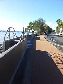
The Esplanade, Urangan | |
 Urangan | |
| Coordinates | 25°18′9″S 152°53′19″E / 25.30250°S 152.88861°ECoordinates: 25°18′9″S 152°53′19″E / 25.30250°S 152.88861°E |
| Population | 9,169 (2011 census)[1] |
| Region | Fraser Coast Region |
Urangan is a suburb of Hervey Bay in Queensland, Australia with the local government authority of Fraser Coast Region. At the 2011 census, Urangan had a population of 9,169.[1]
To the east of the suburb lies the northern end of the Great Sandy Strait and Fraser Island. There is small marina at Urangan. Whale watching tours and ferries to Fraser Island depart from here.
The Hervey Bay railway line once passed through the suburb, terminating at the Urangan Pier. Construction of the Urangan railway line began in 1913. The last ship docked at the Urangan pier in January 1985. In the far south west of the suburb is the single runway Hervey Bay Airport.
Sandy Strait State School was opened in 1995. It is located on the western boundary of the suburb, adjacent to Urangan State High School. The Great Sandy Region Botanic Gardens is located in Urangan on a 26 hectare site.[2] It houses a collection of about 20,000 orchids.
Heritage listings
Urangan has a number of heritage-listed sites, including:
- Miller Street: Urangan Point State School, Block D[3]
See also
References
- ↑ 1.0 1.1 Australian Bureau of Statistics (31 October 2012). "Urangan (State Suburb)". 2011 Census QuickStats. Retrieved 15 July 2013.
- ↑ "Hervey Bay Botanic Gardens". Queensland Holidays. Tourism and Events Queensland. Retrieved 15 July 2013.
- ↑ "Urangan Point State School, Block D (entry 16138)". Queensland Heritage Register. Queensland Heritage Council. Retrieved 2013-07-07.
External links
![]() Media related to Urangan, Queensland at Wikimedia Commons
Media related to Urangan, Queensland at Wikimedia Commons