Uqshapallqa
| Uqshapallqa | |
|---|---|
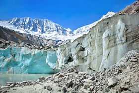 Uqshapallqa (on the left) and Ranrapallqa (on the right), the Llaqa Glacier and Llaqa Lake | |
| Elevation | 5,888 m (19,318 ft) |
| Location | |
 Uqshapallqa Peru | |
| Location | Peru, Ancash Region |
| Range | Andes, Cordillera Blanca |
| Coordinates | 9°24′30″S 77°26′5″W / 9.40833°S 77.43472°WCoordinates: 9°24′30″S 77°26′5″W / 9.40833°S 77.43472°W |
| Climbing | |
| First ascent | 1-1965 via N. ridge: S. face-1979: S. face (new route)-1989.[1] |
Uqshapallqa (Quechua uqsha high altitude grass,[2]pallqa bifurcation, division into two parts, hispanicized spelling Ocshapalca) is a mountain in the Cordillera Blanca in the Andes of Peru, about 5,888 m (19,318 ft) high.[3] It is situated in the Ancash Region, Huaraz Province, on the border of the districts Independencia District and Tarica. Uqshapallqa lies between the mountain Hatunkunka in the west and Ranrapallqa in the east.[4]
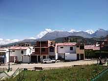
Wallunarahu, Uqshapallqa, Ranrapallqa (the snow covered mountains on the right) as seen from Huaraz
References
- ↑ Taken from Mountaineering in the Andes by Jill Neate, RGS-IBG Expedition Advisory Centre, 2nd edition, May 1994
- ↑ Vocabulario-Comparativo-Quechua-Ecuator-Quechua-Ancash See Spanish: Paja - Ancash Quechua paha, uqsha
- ↑ www.andix.com Map of the Cordillera Blanca
- ↑ escale.minedu.gob.pe - UGEL map of the Huaraz Province (Ancash Region) (unnamed)