Upper Franconia
| Upper Franconia Oberfranken | |
|---|---|
| Regierungsbezirk | |
 Map of Bavaria highlighting the Regierungsbezirk of Upper Franconia | |
| Country | Germany |
| State | Bavaria |
| Region seat | Bayreuth |
| Area | |
| • Total | 7,230.19 km2 (2,791.59 sq mi) |
| Population (31 December 2013)[1] | |
| • Total | 1,056,365 |
| • Density | 150/km2 (380/sq mi) |
| Website | regierung.oberfranken.bayern.de |
Upper Franconia (German: Oberfranken) is a Regierungsbezirk (administrative [Regierungs] region [bezirk]) of the state of Bavaria, southern Germany. It forms part of the historically significant region of Franconia (See also: Middle Franconia and Lower Franconia), all now part of the German Federal State of Bayern (Bavaria).
With more than 200 independent breweries which brew approximately 1000 different types of beer, Upper Franconia has the worlds highest brewery-density per capita. A special Franconian beer route (Fränkische Brauereistraße) leads along popular breweries.
Geography
The administrative region borders on Thuringia (Thüringen) to the north, Lower Franconia (Unterfranken) to the west, Middle Franconia (Mittelfranken) to the south-west, and Upper Palatinate (Oberpfalz) to the south-east, Saxony (Sachsen) to the north-east and the Czech Republic to the east.
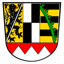
Coat of arms
| The coat of arms displays: |
Administrative subdivisions
Oberfranken is subdivided into a number of Landkreise (districts) and Kreisfreie Städte (district-free or independent cities).
Landkreise:
Kreisfreie Städte:
Historical population of Upper Franconia
| Year | Population |
|---|---|
| 1900 | 608,116 |
| 1910 | 661,862 |
| 1939 | 790,151 |
| 1950 | 1,088,721 |
| 1961 | 1,056,087 |
| 1970 | 1,079,131 |
| 1987 | 1,036,576 |
| 2002 | 1,112,655 |
| 2005 | 1,101,390 |
| 2006 | 1,094,525 |
| 2008 | 1,085,770 |
| 2010 | 1,071,984 |
See also
- Middle Franconia (Mittelfranken)
- Lower Franconia (Unterfranken)
References
- ↑ "Fortschreibung des Bevölkerungsstandes". Bayerisches Landesamt für Statistik und Datenverarbeitung (in German). 31 December 2013.
External links
- Official website (in German)
- Sights in Frankonia (in German)
| ||||||||||||||