Upper Denton
Upper Denton is a small village and civil parish in the north of Cumbria, England about 1 km north of the A69 road linking Haltwhistle and Brampton. The village is situated on the line of the Roman Stanegate which ran from Corbridge (Coria) to Carlisle (Luguvalium). Just 1 km to the north across the river Irthing is Birdoswald fort on Hadrian's Wall. Nearby villages include Gilsland, Greenhead and Lanercost.
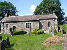
The church was built using Roman stones including a re used Roman Arch. It is said that masonry from Birdoswald was used. [1] The church is no longer in use. The old bastle was at one time a Vicarage. [2]
An accident at the level crossing on December 24th 1970 led to a Department of the Environment report. [3] The level crossing is manned (July 2014) even though there are very few residences on the north side of the line and the road north of the line is a dead end.

References
- ↑ http://www.visitcumbria.com/churches/upper-denton-church/
- ↑ http://www.gatehouse-gazetteer.info/English%20sites/725.html
- ↑ Dept of the Environment 'Report on the accident that occurred on 24th December 1970 at Upper Denton Public Level Crossing between Haltwhistle and Brampton' HMSO
External links
| Wikimedia Commons has media related to Upper Denton. |
- Pictures, and brief details, of the church
- GENUKI page
- Birdoswald Fort, Hadrian's Wall (English Heritage)
- Map sources for Upper Denton
Coordinates: 54°58′54″N 2°36′06″W / 54.98171°N 2.60154°W