Upminster (UK Parliament constituency)
| Upminster | |
|---|---|
|
Former Borough constituency for the House of Commons | |
|
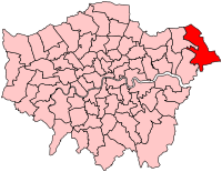
Boundary of Upminster in Greater London for the 2005 general election. | |
| County | Greater London |
| February 1974–2010 | |
| Number of members | One |
| Replaced by | Hornchurch and Upminster |
| Created from | Hornchurch |
Upminster was a constituency of the House of Commons in east London, which returned one Member of Parliament (MP) to the House of Commons of the Parliament of the United Kingdom, elected by the first-past-the-post voting system. It was created for the 1974 general election and abolished for the 2010 general election
History
This usually safe Conservative seat was won by Labour in the landslide of 1997. It became one of the few seats that Labour lost in the 2001 general election.
Boundaries
1974-1983: The London Borough of Havering wards of Cranham, Emerson Park, Gooshays, Harold Wood, Heaton, Hilldene, and Upminster.
1983-1997: The London Borough of Havering wards of Ardleigh Green, Cranham East, Cranham West, Emerson Park, Gooshays, Harold Wood, Heaton, Hilldene, and Upminster.
1997-2010: The London Borough of Havering wards of Cranham East, Cranham West, Emerson Park, Gooshays, Harold Wood, Heaton, Hilldene, and Upminster.
Upminster was the easternmost constituency of the London Borough of Havering, and of Greater London. The constituency was oddly shaped and covered both the wealthiest and the poorest parts of the borough while being London's least ethnically diverse constituency.
The constituency included the Upminster suburb of Cranham. The boundary to the north extended beyond the A127 and A12 to include Harold Wood and Harold Hill. In the east the constituency was uniquely the only London constituency form a protrusion to cross the M25 motorway and include North Ockendon. To the west the boundary also formed a protrusion to include the wealthy suburban area of Emerson Park which otherwise formed part of Hornchurch. The River Ingrebourne formed part of the constituency boundary to the west and the M25 Motorway formed much of the boundary to the east.
The constituency was replaced by the new Hornchurch and Upminster constituency for the 2010 general election.
Members of Parliament
| Election | Member[1] | Party | |
|---|---|---|---|
| Feb 1974 | John Loveridge | Conservative | |
| 1983 | Sir Nicholas Bonsor | Conservative | |
| 1997 | Keith Darvill | Labour | |
| 2001 | Angela Watkinson | Conservative | |
| 2010 | constituency abolished: see Hornchurch and Upminster | ||
Elections
Elections in the 2000s
| General Election 2005: Upminster | |||||
|---|---|---|---|---|---|
| Party | Candidate | Votes | % | ±% | |
| Conservative | Angela Watkinson | 16,820 | 48.5 | +3.0 | |
| Labour | Keith Darvill | 10,778 | 31.1 | −10.8 | |
| Liberal Democrat | Peter Truesdale | 3,128 | 9.0 | −0.4 | |
| Residents | Ron Ower | 1,455 | 4.2 | +4.2 | |
| BNP | Chris Roberts | 1,173 | 3.4 | +3.4 | |
| UKIP | Alan Hindle | 701 | 2.0 | −1.2 | |
| Green | Melanie Collins | 543 | 1.6 | +1.6 | |
| Third Way | David Durant | 78 | 0.2 | +0.2 | |
| Majority | 6,042 | 17.4 | +14.8 | ||
| Turnout | 34,676 | 63.0 | +3.4 | ||
| Conservative hold | Swing | +6.9 | |||
| General Election 2001: Upminster | |||||
|---|---|---|---|---|---|
| Party | Candidate | Votes | % | ±% | |
| Conservative | Angela Watkinson | 15,410 | 45.5 | +6.0 | |
| Labour | Keith Darvill | 14,169 | 41.9 | -4.3 | |
| Liberal Democrat | Peter Jonathan Truesdale | 3,183 | 9.4 | -0.1 | |
| UKIP | Terry Murray | 1,089 | 3.2 | N/A | |
| Majority | 1,241 | 3.6 | −3.1 | ||
| Turnout | 33,851 | 59.6 | -13.2 | ||
| Conservative gain from Labour | Swing | +5.2 | |||
Elections in the 1990s
| General Election 1997: Upminster[2][3][4] | |||||
|---|---|---|---|---|---|
| Party | Candidate | Votes | % | ±% | |
| Labour | Keith Darvill | 19,095 | 46.2 | +16.1 | |
| Conservative | Sir Nicholas Bonsor | 16,315 | 39.5 | −14.7 | |
| Liberal Democrat | Pamela Peskett | 3,919 | 9.5 | −6.2 | |
| Referendum Party | Terry Murray | 2,000 | 4.8 | N/A | |
| Majority | 2,770 | 6.7 | −17.4 | ||
| Turnout | 41,319 | 72.3 | |||
| Labour gain from Conservative | Swing | +15.4 | |||
Elections in the 1980s
| General Election 1987: Upminster[5] | |||||
|---|---|---|---|---|---|
| Party | Candidate | Votes | % | ±% | |
| Conservative | Sir Nicholas Bonsor | 27,946 | 55.8 | ||
| Social Democratic | J Martin | 11,089 | 22.1 | ||
| Labour | D R O'Flynn | 11,069 | 22.1 | ||
| Majority | 16,857 | 33.6 | |||
| Turnout | 75.2 | ||||
| General Election 1983: Upminster[6] | |||||
|---|---|---|---|---|---|
| Party | Candidate | Votes | % | ±% | |
| Conservative | Sir Nicholas Bonsor | 25,153 | 52.5 | ||
| Social Democratic | D Osman | 12,339 | 25.8 | ||
| Labour | A Hughes | 9,829 | 20.5 | ||
| National Front | G Nobes-Price | 566 | 1.2 | ||
| Majority | 12,814 | 26.8 | |||
| Turnout | 72.1 | ||||
See also
- List of Parliamentary constituencies in Greater London
Notes and references
- ↑ Leigh Rayment's Historical List of MPs – Constituencies beginning with "U"
- ↑ "Politics Resources". Election 1997. Politics Resources. 1 May 1997. Retrieved 2011-01-10.
- ↑ C. Rallings & M. Thrasher, The Media Guide to the New Parliamentary Constituencies, p.167 (Plymouth: LGC Elections Centre, 1995)
- ↑ The 1997 election result is calculated relative to the notional, not the actual, 1992 result.
- ↑ "Politics Resources". Election 1987. Politics Resources. Retrieved 2013-04-14.
- ↑ "Politics Resources". Election 1987. Politics Resources. Retrieved 2013-04-14.