Upham Parish, New Brunswick
| Upham | |
|---|---|
| Parish | |
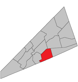 Location within Kings County, New Brunswick. | |
| Coordinates: 45°50′N 64°35′W / 45.84°N 64.59°W | |
| Country |
|
| Province |
|
| County | Kings County |
| Established | 1835 |
| Area[1] | |
| • Land | 188.55 km2 (72.80 sq mi) |
| Population (2011)[1] | |
| • Total | 1,306 |
| • Density | 6.9/km2 (18/sq mi) |
| • Pop 2006-2011 |
|
| • Dwellings | 563 |
| Time zone | AST (UTC-4) |
| • Summer (DST) | ADT (UTC-3) |
This article is about the parish. For the community, consult Upham, New Brunswick.
Upham is a Canadian parish in Kings County, New Brunswick.
History
Upham Parish was established in 1835: named for Joshua Upham (1741-1808), a Loyalist officer in the King's American Dragoons, a Harvard law graduate, and a judge of the New Brunswick supreme court in 1784: included Hammond Parish until 1858.
Delineation
Upham Parish is defined in the Territorial Division Act as:
Communities
Parish population total does not include incorporated municipalities (in bold):
|
|
|
Bodies of water & Islands
This is a list of rivers, lakes, streams, creeks, marshes and Islands that are at least partially in this parish
Demographics
PopulationPopulation trend[2]
|
LanguageMother tongue language (2006)[3]
|
Access Routes
Highways and numbered routes that run through the parish, including external routes that start or finish at the parish limits:[4]
|
|
|
See also
References
- ↑ 1.0 1.1 2011 Statistics Canada Census Profile: Upham Parish, New Brunswick
- ↑ Statistics Canada: 2001, 2006 census
- ↑ Profile: Upham Parish, New Brunswick
- ↑ Atlantic Canada Back Road Atlas ISBN 978-1-55368-618-7
 |
Norton Parish | Sussex Parish | | |
| Hampton Parish | |
Hammond Parish | ||
| ||||
| | ||||
| Simonds Parish | Saint Martins Parish |
| ||||||||||||||||||
Coordinates: 45°30′47″N 65°39′30″W / 45.513144°N 65.658331°W