Upernivik Island
For Upernavik island, see Upernavik.
|
Location of Upernivik Island | |
| Geography | |
|---|---|
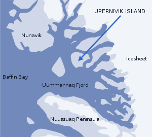
| Location | Uummannaq Fjord |
| Coordinates | 71°16′N 52°45′W / 71.267°N 52.750°WCoordinates: 71°16′N 52°45′W / 71.267°N 52.750°W |
| Area | 540 km2 (210 sq mi) |
| Country | |
| Municipality | Qaasuitsup |

Aerial view of southwestern Upernivik Island
Upernivik Island is an uninhabited[1] island in the Qaasuitsup municipality in northwestern Greenland. At 540 km2 (208.5 sq mi),[1] it is the largest island in the Uummannaq Fjord area, located in its northern part.[2] Upernivik island is very mountainous. Its highest point is Palup Qaqqaa, at 2,105 m (6,906.2 ft).
References
| Wikimedia Commons has media related to Upernivik Island. |
- ↑ 1.0 1.1 Norwegian University of Science and Technology
- ↑ Nuussuaq, Saga Map, Tage Schjøtt, 1992