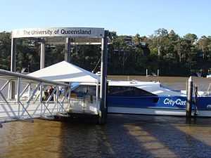
University of Queensland ferry wharf
University of Queensland | |||||||||||
|---|---|---|---|---|---|---|---|---|---|---|---|
 | |||||||||||
| Location | Sir William Macgregor Drive, St Lucia | ||||||||||
| Coordinates | 27°29′37″S 153°01′00″E / 27.4937°S 153.0166°ECoordinates: 27°29′37″S 153°01′00″E / 27.4937°S 153.0166°E | ||||||||||
| Owned by | Brisbane City Council | ||||||||||
| Platforms | 1 | ||||||||||
| Other information | |||||||||||
| Fare zone | 2 (TransLink) | ||||||||||
| Services | |||||||||||
| |||||||||||
University of Queensland is a ferry wharf in the suburb of St Lucia used by the CityCat on the Brisbane River.
A non-TransLink cross river ferry service formerly ran between UQ and Dutton Park, but was discontinued when the bus, cyclist and pedestrian only Eleanor Schonell Bridge adjacent to the route was completed.
In January 2011 the wharf was destroyed during the devastating floods and the rebuilding works were expected to take months.[1]
The terminal was re-opened on 18 April after temporary measures were put in place by the Brisbane City Council to restore CityCat operations.[2]
References
- ↑ "CityCat, CityFerry terminal damage". Brisbane Times. 20 January 2011. Retrieved 27 January 2011.
- ↑ "All CityCat terminals except West End get back on deck". The Courier-Mail. 18 April 2011. Retrieved 7 May 2011.
External links
| Wikimedia Commons has media related to University of Queensland ferry wharf. |
| ||||||