United States National Radio Quiet Zone
The National Radio Quiet Zone (NRQZ) is a large area of land in the United States in which radio transmissions are strongly restricted by law, to facilitate scientific research and military intelligence.
Location
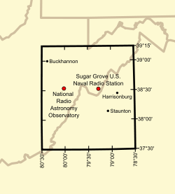
The Quiet Zone is a rectangle of land, approximately 13,000 square miles (34,000 km2) in size. It straddles the borders of Virginia and West Virginia, and also includes a sliver of Maryland. The NRQZ is centered between the National Radio Astronomy Observatory (NRAO) in Green Bank, West Virginia, and Sugar Grove Station in Sugar Grove, West Virginia. It includes all land with latitudes between 37° 30′ 0.4″ N and 39° 15′ 0.4″ N, and longitudes between 78° 29′ 59.0″ W and 80° 29′ 59.2″ W.[1]
Restrictions
Most broadcast transmitters in the Quiet Zone are forced to operate at reduced power and use highly directional antennas. This makes cable and satellite all but essential for acceptable television in much of the region. Restrictions on transmissions are tightest within ten miles of the NRAO and Sugar Grove facilities,[2] where most omnidirectional and high-power transmissions are prohibited.
Chapter 37A of the West Virginia Code strictly regulates radio transmitters within 10 miles of the NRAO facility.[2] Staff of the NRAO routinely patrol radio transmissions within a 20-mile radius of the Green Bank Telescope.[3]
Not all radio transmissions are prohibited in the Radio Quiet Zone. For example, emergency service (police, fire, and ambulance) radios and Citizen's Band radio are permitted. However, large transmitter owners must typically coordinate their operations with the NRAO. The only broadcast radio stations in the inner core of the Quiet Zone are part of the Allegheny Mountain Radio network—with just one station in the AM band, and several low-power FM stations. Exceptions to the Quiet Zone restrictions are usually determined on a case-by-case basis, with preference given to public safety concerns, such as remote alarm systems, repeaters for emergency services, and NOAA Weather Radio.
Uses
The Quiet Zone was created by the Federal Communications Commission (FCC) in 1958 to protect the radio telescopes at Green Bank and Sugar Grove from harmful interference. Today, the NRAO oversees the Quiet Zone, in agreement with the Sugar Grove facility.
The Quiet Zone protects the telescopes of the NRAO facility, and the antennas and receivers of the U.S. Navy's Information Operations Command (NIOC) at Sugar Grove. The NIOC has long been the location of electronic intelligence-gathering systems, and is today said to be a key station in the ECHELON system operated by the National Security Agency (NSA).[4]
The area has also attracted people who believe they suffer from electromagnetic hypersensitivity.[5]
Counties inside the Zone
Maryland counties
- Extreme southern Garrett County
Virginia counties
- See also List of radio stations in Virginia, which includes several AM and FM stations within the zone.
- Western Albemarle County
- Alleghany County
- Amherst County, except for the southern quarter
- Extreme northern Appomattox County
- Augusta County
- Bath County
- Extreme northern Bedford County
- Northern Botetourt County
- Northwestern Buckingham County
- Northern Craig County
- Western Greene County
- Highland County
- Nelson County
- Western Page County
- Rockbridge County
- Rockingham County, except for a small area in the extreme eastern part
- Western Shenandoah County
West Virginia counties
- See also List of radio stations in West Virginia, which includes several AM and FM stations within the zone.
- Barbour County, except for a small area in the north
- Extreme eastern Braxton County
- Grant County, except for an area in the north
- Eastern Greenbrier County
- Southwestern Hampshire County
- Hardy County
- Southeastern Harrison County
- Eastern Lewis County
- Extreme southern Mineral County
- Northeastern and east central Monroe County
- Extreme eastern Nicholas County
- Pendleton County
- Pocahontas County
- Two areas in extreme southwestern and southeastern Preston County
- Randolph County
- Extreme southern Taylor County
- Tucker County, except for an area in the extreme northern part
- Upshur County
- Central and eastern Webster County
Cities inside the Zone
Virginia cities
- Buena Vista
- The western half of Charlottesville, including much of the University of Virginia Grounds
- Covington
- Harrisonburg
- Lexington
- Staunton
- Waynesboro
West Virginia cities
Clarksburg, West Virginia, and Lynchburg, Virginia are just outside the Quiet Zone.
See also
References
- ↑ "National Radio Quiet Zone". National Radio Astronomy Observatory. Retrieved February 20, 2015.
- ↑ 2.0 2.1 "West Virginia Code, Chapter 37A". Chuck Niday - National Radio Astronomy Observatory. Retrieved 2013-10-08.
- ↑ Elise Hu (Oct 8, 2013). "Enter The Quiet Zone: Where Cell Service, Wi-Fi Are Banned". National Public Radio. Retrieved 2013-10-08.
To keep the zone protected from signals that could confuse the telescope, Niday and others from the NRAO drive the 20-mile radius around the Green Bank Telescope weekly, policing for possible interference.
- ↑ "Interception Capabilities 2000, Sugar Grove, Virginia – COMSAT interception at ECHELON site". Interception of Communications Section. Leeds, UK: Cyber-Rights & Cyber-Liberties (UK). May 11, 1999. Archived from the original on May 30, 2008. Retrieved September 14, 2011.
Interception Capabilities 2000 Report to the Director General for Research of the European Parliament (Scientific and Technical Options Assessment programme office) on the development of surveillance technology and risk of abuse of economic information.
- ↑ O'Brien, Jane; Danzico, Matt (September 12, 2011). "'Wi-fi refugees' shelter in West Virginia mountains". BBC News. Retrieved September 13, 2011.
External links
- "National Radio Quiet Zone". National Radio Astronomy Observatory. Retrieved February 20, 2015. - Official website
Coordinates: 38°22′30″N 79°30′00″W / 38.375°N 79.5°W
- The Town Without Wi-Fi—Washingtonian (January 2015)