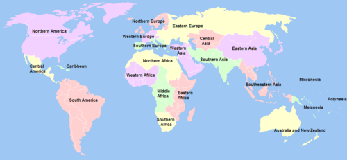
United Nations geoscheme

The definition of regions and subregions in use by the United Nations for statistical purposes. Antarctica is omitted.
The United Nations geoscheme is a scheme devised by the United Nations Statistics Division (UNSD) based on the M49 coding classification, which divides the world into macro-geographical regions and subregions.[1]
The schema was devised for statistical analysis and consists of macro-geographical regions arranged to the extent possible according to continents. Within these groupings, smaller, geographical subregions and selected economic and other groupings allow for detailed analysis. The UNSD notes that "the assignment of countries or areas to specific groupings is for statistical convenience and does not imply any assumption regarding political or other affiliation of countries or territories".[2]
List of regions and subregions
- Africa – see also: UN geoscheme for Africa
- Americas – see also: UN geoscheme for the Americas
- Latin America and the Caribbean
- Northern America *
- * These three subregions together form the continent of North America.[1]
- Antarctica
- Asia ** – see also: UN geoscheme for Asia
- Europe ** – see also: UN geoscheme for Europe
- Eastern Europe - UN includes North Asia (the Asian portion of Russia) in this subregion
- Northern Europe
- Southern Europe
- Western Europe
- ** These two regional continents form the geographic continent of Eurasia which is not part of the UN geoscheme.
- Oceania – see also: UN geoscheme for Oceania
See also
- Geopolitical divisions of Europe
- United Nations Regional Groups
- United Nations Statistics Division
- UN M.49