Union Township, Vanderburgh County, Indiana
| Union Township Vanderburgh County | |
|---|---|
| Township | |
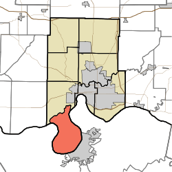 Location in Vanderburgh County | |
| Coordinates: 37°52′31″N 87°37′50″W / 37.87528°N 87.63056°WCoordinates: 37°52′31″N 87°37′50″W / 37.87528°N 87.63056°W | |
| Country | United States |
| State | Indiana |
| County | Vanderburgh |
| Government | |
| • Type | Indiana township |
| Area | |
| • Total | 28.09 sq mi (72.8 km2) |
| • Land | 27.54 sq mi (71.3 km2) |
| • Water | 0.55 sq mi (1.4 km2) 1.96% |
| Elevation | 361 ft (110 m) |
| Population (2010) | |
| • Total | 292 |
| • Density | 10.6/sq mi (4.1/km2) |
| ZIP code | 47712 |
| GNIS feature ID | 0453937 |
Union Township is the most sparsely populated of the eight townships in Vanderburgh County, Indiana, USA. As of the 2010 census, its population was 292 and it contained 227 housing units.[1] This is largely due to the entire township being located within the Ohio River Floodplain.
Geography
According to the 2010 census, the township has a total area of 28.09 square miles (72.8 km2), of which 27.54 square miles (71.3 km2) (or 98.04%) is land and 0.55 square miles (1.4 km2) (or 1.96%) is water.[1]
Adjacent townships
- Perry Township (north)
Cemeteries
The township contains Stroud Cemetery.
Rivers
School districts
- Evansville-Vanderburgh School Corporation
Political districts
- Indiana's 8th congressional district
- State House District 76
- State Senate District 49
References
- "Union Township, Vanderburgh County, Indiana". Geographic Names Information System. United States Geological Survey. Retrieved 2010-02-20.
- United States Census Bureau 2007 TIGER/Line Shapefiles
- IndianaMap
- ↑ 1.0 1.1 "Population, Housing Units, Area, and Density: 2010 - County -- County Subdivision and Place -- 2010 Census Summary File 1". United States Census. Retrieved 2013-05-10.
External links
 |
Perry Township | | ||
| |
||||
| ||||
| | ||||
| |
| |||||||||||||||||||||||||||||||||