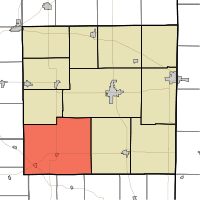
Union Township, Randolph County, Indiana
| Union Township | |
|---|---|
| Township | |
 Location of Union Township | |
| Coordinates: 40°2′39″N 85°7′41″W / 40.04417°N 85.12806°WCoordinates: 40°2′39″N 85°7′41″W / 40.04417°N 85.12806°W | |
| Country | United States |
| State | Indiana |
| County | Randolph |
| Government | |
| • Type | Indiana township |
| Area | |
| • Total | 71.65 sq mi (185.6 km2) |
| • Land | 71.52 sq mi (185.2 km2) |
| • Water | 0.13 sq mi (0.3 km2) |
| Elevation | 1,145 ft (349 m) |
| Population (2010) | |
| • Total | 2,142 |
| • Density | 30/sq mi (10/km2) |
| Time zone | Eastern (EST) (UTC-5) |
| • Summer (DST) | EDT (UTC-4) |
| FIPS code | 18-77588[1] |
| GNIS feature ID | 0453931[2] |
Union Township is one of eleven townships in Randolph County, Indiana, which contains the towns of Modoc and Losantville. As of the 2010 census, its population was 2,142 and it contained 960 housing units.[3] It was formerly divided into two separate townships, Nettle Creek Township (which included Losantville) and West River Township (which included Modoc).
Geography
According to the 2010 census, the township has a total area of 71.65 square miles (185.6 km2), of which 71.52 square miles (185.2 km2) (or 99.82%) is land and 0.13 square miles (0.34 km2) (or 0.18%) is water.[3]
Cemeteries
Union Township has nine cemeteries:
- Buena Vista Cemetery
- Huntsville Cemetery
- Little Creek Cemetery
- Nettle Creek Baptist Cemetery
- Riverside Cemetery
- Salem Cemetery
- Scott Cemetery
- Union Baptist Cemetery
- Union Chapel Cemetery
Union High School (Modoc)
Union High School (Modoc) is a small high school located in Union Township, Modoc, Indiana. Although the official name is Union Township High School. It is one of five high schools in Randolph County, Indiana. In 2004 Union High School was named an Indiana Four Star School by the Indiana Department of Education. The school is a member of the Indiana High School Athletic Association (IHSAA), which is the governing body for high school sports in the state of Indiana.
Major highways
References
- ↑ "American FactFinder". United States Census Bureau. Retrieved 2008-01-31.
- ↑ "US Board on Geographic Names". United States Geological Survey. 2007-10-25. Retrieved 2008-01-31.
- ↑ 3.0 3.1 "Population, Housing Units, Area, and Density: 2010 - County -- County Subdivision and Place -- 2010 Census Summary File 1". United States Census. Retrieved 2013-05-10.
External links
 |
Perry-Delaware | Stoney Creek-Randolph | White River-Randolph |  |
| Stoney Creek-Henry | |
Washington-Randolph | ||
| ||||
| | ||||
| Blue River-Henry, Dalton-Wayne | Perry-Wayne | Green-Wayne |
| |||||||||||||||||||||||||||||