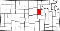
Union Township, Dickinson County, Kansas
| Union Township | |
|---|---|
| Township | |
 Location in Dickinson County | |
| Coordinates: 38°44′25″N 096°59′01″W / 38.74028°N 96.98361°WCoordinates: 38°44′25″N 096°59′01″W / 38.74028°N 96.98361°W | |
| Country | United States |
| State | Kansas |
| County | Dickinson |
| Area | |
| • Total | 36.18 sq mi (93.7 km2) |
| • Land | 36.11 sq mi (93.52 km2) |
| • Water | 0.07 sq mi (0.19 km2) 0.2% |
| Elevation | 1,296 ft (395 m) |
| Population (2000) | |
| • Total | 176 |
| • Density | 4.9/sq mi (1.9/km2) |
| GNIS feature ID | 0476862 |
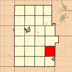
Union Township is a township in Dickinson County, Kansas, USA. As of the 2000 census, its population was 176.
Geography
Union Township covers an area of 36.18 square miles (93.7 km2) and contains no incorporated settlements. According to the USGS, it contains one cemetery, Saint Paul.
The streams of Lime Creek and West Branch Lyon Creek run through this township.
Further reading
References
External links
| |||||||||||||||||||||||||||||