Unicoi, Tennessee
| Unicoi, Tennessee | |
|---|---|
| Town | |
|
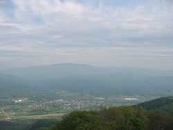
Unicoi viewed from Buffalo Mountain | |
 Location of Unicoi, Tennessee | |
| Coordinates: 36°13′12″N 82°20′17″W / 36.22000°N 82.33806°WCoordinates: 36°13′12″N 82°20′17″W / 36.22000°N 82.33806°W | |
| Country | United States |
| State | Tennessee |
| County | Unicoi |
| Incorporated | 1994[1] |
| Named for | Unaka, Cherokee for "white"[2] |
| Area | |
| • Total | 16.3 sq mi (42.1 km2) |
| • Land | 16.3 sq mi (42.1 km2) |
| • Water | 0.0 sq mi (0.0 km2) |
| Elevation | 1,923 ft (586 m) |
| Population (2010) | |
| • Total | 3,632 |
| • Density | 216.4/sq mi (83.5/km2) |
| Time zone | Eastern (EST) (UTC-5) |
| • Summer (DST) | EDT (UTC-4) |
| ZIP code | 37692 |
| Area code(s) | 423 |
| FIPS code | 47-75820[3] |
| GNIS feature ID | 1304219[4] |
Unicoi is a town in Unicoi County, Tennessee, United States. The population was 3,519 at the 2000 census and 3,632 at the 2010 census. It is part of the Johnson City Metropolitan Statistical Area, which is a component of the Johnson City–Kingsport–Bristol, TN-VA Combined Statistical Area – commonly known as the "Tri-Cities" region.
Geography
Unicoi is located at 36°13′12″N 82°20′17″W / 36.22000°N 82.33806°W (36.220028, -82.338138).[5]
According to the United States Census Bureau, the town has a total area of 16.3 square miles (42 km2), all of it land.
Demographics
| Historical population | |||
|---|---|---|---|
| Census | Pop. | %± | |
| 2000 | 3,519 | — | |
| 2010 | 3,632 | 3.2% | |
| Est. 2012 | 3,640 | 0.2% | |
| Sources:[6][7] | |||
As of the census[3] of 2000, there were 3,519 people, 1,452 households, and 1,052 families residing in the town. The population density was 216.4 people per square mile (83.6/km²). There were 1,562 housing units at an average density of 96.0 per square mile (37.1/km²). The racial makeup of the town was 97.76% White, 0.06% African American, 0.31% Native American, 0.23% Asian, 0.03% Pacific Islander, 1.05% from other races, and 0.57% from two or more races. Hispanic or Latino of any race were 2.22% of the population.
There were 1,452 households out of which 29.2% had children under the age of 18 living with them, 62.1% were married couples living together, 7.1% had a female householder with no husband present, and 27.5% were non-families. 23.2% of all households were made up of individuals and 8.8% had someone living alone who was 65 years of age or older. The average household size was 2.42 and the average family size was 2.88.
In the town the population was spread out with 22.3% under the age of 18, 8.2% from 18 to 24, 29.7% from 25 to 44, 27.4% from 45 to 64, and 12.5% who were 65 years of age or older. The median age was 39 years. For every 100 females there were 104.6 males. For every 100 females age 18 and over, there were 99.0 males.
The median income for a household in the town was $29,483, and the median income for a family was $40,208. Males had a median income of $31,299 versus $19,052 for females. The per capita income for the town was $15,870. About 9.7% of families and 13.2% of the population were below the poverty line, including 16.0% of those under age 18 and 19.9% of those age 65 or over.
References
- ↑ Tennessee Blue Book, 2005-2006, pp. 618-625.
- ↑ Nancy Capace, Encyclopedia of Tennessee (North American Book Distributors, 2000), p. 226.
- ↑ 3.0 3.1 "American FactFinder". United States Census Bureau. Retrieved 2008-01-31.
- ↑ "US Board on Geographic Names". United States Geological Survey. 2007-10-25. Retrieved 2008-01-31.
- ↑ "US Gazetteer files: 2010, 2000, and 1990". United States Census Bureau. 2011-02-12. Retrieved 2011-04-23.
- ↑ "Census of Population and Housing: Decennial Censuses". United States Census Bureau. Retrieved 2012-03-04.
- ↑ "Incorporated Places and Minor Civil Divisions Datasets: Subcounty Resident Population Estimates: April 1, 2010 to July 1, 2012". Population Estimates. U.S. Census Bureau. Retrieved 11 December 2013.
| |||||||||||||||||||||||||