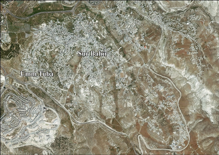
Umm Tuba
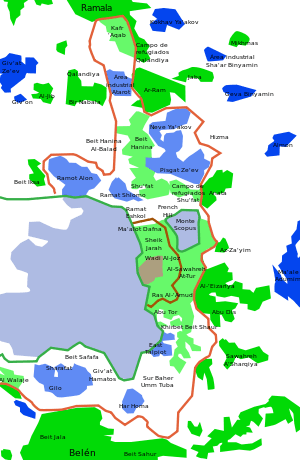
Umm Tuba (Arabic: أم طوبا)[1] is an Arab neighborhood in East Jerusalem part of Sur Baher; it is northeast of Har Homa and Bethlehem, and southeast of Kibbutz Ramat Rachel.[2] It has a population of 4,000. After the 1967 Six-Day War, Umm Tuba was incorporated into the municipal district of Jerusalem. Based on archaeological finds, Umm Tuba was the site of the biblical city of Netophah.
Etymology
The name of the Arab village, "Umm Tuba," is derived from the Byzantine era name, "Metofa," itself a derivation of the name Netofa. Netofa is mentioned in the Bible as the place from which two of King David's heroes originated (2Samuel 23:28-29).[3][4]
History
Biblical history
Netofa was a prosperous Judean farming village in the period of the First Temple.[3] An archaeological dig uncovered at least three royal seal impressions dating from the reign of Hezekiah, King of Judah (eighth century BCE). At least two "LMLK" (belonging to the King) impressions and two personal seal impressions were discovered on handles of large jars of the type used to store wine and olive oil. Artifacts dating to the Hasmonean period was also found.[3]
Impressive remains of a Byzantine-era monastery have been found, which has been taken as proof that Umm Tuba was the site of “Metofa”, a place mentioned in the writings of Church elders in the Byzantine period.[3][4]
Bell-shaped cisterns dug into rock have been discovered. Several tombs carved into rock, one with stone entrance has also been found, to together with Byzantine ceramics.[5]
Ottoman period
In 1596, Umm Tuba appeared in Ottoman tax registers as being in the Nahiya of Quds of the Liwa of Quds. It had a population of 36 Muslim households and paid taxes on wheat, barley, olives, vines or fruit trees, and goats or beehives.[6]
French explorer Victor Guérin visited the place in 1863, and described caves and other possible remains from a Christian period.[7] In 1883, the Palestine Exploration Fund's Survey of Western Palestine described the village as "an ancient site with bell-mouthed cisterns and ruins of modern buildings. To the east is a Mukam of Neby Toda."[8]
British mandate period
In 1945 the population of Umm Tuba, together with Sur Baher, was 2,450, all Arabs, who owned 8,915 dunams of land according to an official land and population survey.[9] 911 dunams were plantations and irrigable land, 3,927 used for cereals,[10] while 56 dunams were built-up (urban) land.[11]
Modern period
Many refugees came to Umm Tuba after the 1948 Arab–Israeli War.[12]
Education
In 2005, a minefield on the outskirts of Umm Tuba was cleared of hundreds of Jordanian mines by Israel to ready the site for the construction of a new high school.[13] The Wingate Charitable Trust has established a joint Jewish-Arab project in which fifth and sixth graders from Umm Tuba and Kiryat HaYovel study science together. At each meeting the children learn about a scientific concept, while becoming acquainted with each other's language and culture.[14] Through the Abraham Project at the Bible Lands Museum in Givat Ram, fourth graders from Umm Tuba meet with their Jewish peers to learn about their common ancestor, Abraham/Ibrahim.[15] In 2012, Umm Tuba Elementary School took part in an environmental water conservation project financed by the Jerusalem Foundation.[16]
Demography
In 2008, Prof. Tamar Rapoport and Afnan Masarwah of the Hebrew University of Jerusalem presented their research on changing perspectives of motherhood, children and family relationships among women in Umm Tuba.[17]
Notable residents
References
- ↑ Meaning possibly: "The ruin with the good tree or water", according to Palmer, 1881, p. 312
- ↑ Jerusalem Neighborhoods
- ↑ 3.0 3.1 3.2 3.3 Royal seal impressions from the First Temple period discovered south of Jerusalem, 23 Feb 2009
- ↑ 4.0 4.1 Greetings from Ahimelekh and Yehokhil, from Netofa in Judah (23/2/2009), Israel Antiques Authority
- ↑ Dauphin, 1998, p. 911
- ↑ Hütteroth and Abdulfattah, 1977, p. 117
- ↑ Guérin, 1869, p. 83-85
- ↑ Conder and Kitchener, 1883, p. 128
- ↑ Government of Palestine, Department of Statistics. Village Statistics, April, 1945. Quoted in S. Hadawi, Village Statistics, 1945. PLO Research Center, 1970, p. 58
- ↑ Government of Palestine, Department of Statistics. Village Statistics, April, 1945. Quoted in S. Hadawi, Village Statistics, 1945. PLO Research Center, 1970, p. 104
- ↑ Government of Palestine, Department of Statistics. Village Statistics, April, 1945. Quoted in S. Hadawi, Village Statistics, 1945. PLO Research Center, 1970, p. 154
- ↑ Jerualem Neighborhoods
- ↑ Minefield cleared for new Arab school, Jerusalem Post
- ↑ The Universal Language of Science
- ↑ 'Abraham' Project Brings Jewish, Muslim Kids Together, CBS
- ↑ Rainwater Harvesting
- ↑ NCJW Research Institute for Innovation in Education
- ↑ Hamas' hair apparent, Haaretz
Bibliography
- Barron, J. B., ed. (1923). Palestine: Report and General Abstracts of the Census of 1922. Government of Palestine.
- Conder, Claude Reignier; Kitchener, Herbert H. (1883). The Survey of Western Palestine: Memoirs of the Topography, Orography, Hydrography, and Archaeology 3. London: Committee of the Palestine Exploration Fund.
- Dauphin, Claudine (1998). La Palestine byzantine, Peuplement et Populations. BAR International Series 726 (in French). III : Catalogue. Oxford: Archeopress.
- Guérin, Victor (1869). Description Géographique Historique et Archéologique de la Palestine (in French). 1: Judee, pt. 3. Paris: L'Imprimerie Nationale.
- Hadawi, Sami (1970). Village Statistics of 1945: A Classification of Land and Area ownership in Palestine. Palestine Liberation Organization Research Center.
- Hütteroth, Wolf-Dieter; Abdulfattah, Kamal (1977). Historical Geography of Palestine, Transjordan and Southern Syria in the Late 16th Century. Erlanger Geographische Arbeiten, Sonderband 5. Erlangen, Germany: Vorstand der Fränkischen Geographischen Gesellschaft. ISBN 3-920405-41-2.
- Kagan, Evgeni D.; Eirikh-Rose, Anna (2012-03-26), Jerusalem, Umm Tuba Final Report (124), Hadashot Arkheologiyot – Excavations and Surveys in Israel
- Mills, E., ed. (1932). Census of Palestine 1931. Population of Villages, Towns and Administrative Areas. Jerusalem: Government of Palestine.
- Palmer, E. H. (1881). The Survey of Western Palestine: Arabic and English Name Lists Collected During the Survey by Lieutenants Conder and Kitchener, R. E. Transliterated and Explained by E.H. Palmer. Committee of the Palestine Exploration Fund.
External links
- Welcome To Sur Bahir & Umm Tuba
- SWP map XVII, IAA
- SWP map 17, Wikimedia commons
- Sur Bahir and Umm Tuba (Fact Sheet), ARIJ
- Sur Bahir & Umm Tuba Town Profile, ARIJ
- Sur Bahir & Umm Tuba Areal photo, ARIJ
- Construction at a New Location on Abu Ghnaim Mountain (Har Homa Settlement) 18, November, 2000, ARIJ
- The snaking Wall enters area (A) in Bethlehem 04, December, 2003, ARIJ
- House Demolition in East Jerusalem during the month of August 30, September, 2004, ARIJ
- House demolition cases and testimonies from Jerusalem 19, September, 2006, ARIJ
