Umaji, Kōchi
| Umaji 馬路村 | |
|---|---|
| Village | |
 Location of Umaji in Kōchi Prefecture | |
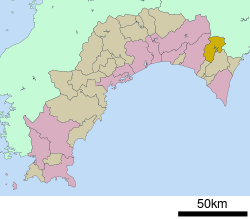
 Umaji Location in Japan | |
| Coordinates: 33°33′N 134°3′E / 33.550°N 134.050°ECoordinates: 33°33′N 134°3′E / 33.550°N 134.050°E | |
| Country | Japan |
| Region | Shikoku |
| Prefecture | Kōchi Prefecture |
| District | Aki |
| Government | |
| • Mayor | Takashi Kamiji |
| Area | |
| • Total | 165.52 km2 (63.91 sq mi) |
| Population (December 1, 2012) | |
| • Total | 941 |
| • Density | 5.7/km2 (15/sq mi) |
| Time zone | Japan Standard Time (UTC+9) |
| Symbols | |
| - Tree | Cryptomeria |
| - Flower | Yuzu |
| - Bird | Blue-and-White Flycatcher |
| Address |
443 Umaji, Umaji-mura, Kōchi-ken 781-6201 |
| Phone number | 0887-44-2111 |
| Website | Village of Umaji |
Umaji (馬路村 Umaji-mura) is a village located in Aki District, Kōchi Prefecture, Japan.
As of December 1, 2012, the village has an estimated population of 941 and a density of 5.69 persons per km². The total area is 165.52 km².
Geography
Umaji is located in a mountainous region, and the Yasuda River flows through. Approximately 96% of the village is covered by forests, 75% of which are protected by the government. Major mountains include Mount Eboshi (1,320 m) and Jinkichimori (1,423 m).
Umaji is part of the local area called Chugei 中芸 which includes Umaji, Yasuda, Tano, Nahari and Kitagawa.
Neighboring municipalities
Education
- Junior High Schools
- Umaji Junior High School
- Yanase Junior High School
- Primary Schools
- Umaji Elementary School
- Yanase Elementary School
Access
Access is only by car or bus. Umaji's local train station is in Yasuda which is about a 30 minute drive away. Yasuda is on the Gomen-Nahari Line.[1]
References
External links
![]() Media related to Umaji, Kōchi at Wikimedia Commons
Media related to Umaji, Kōchi at Wikimedia Commons
- Umaji official website (Japanese)
| |||||||||||||||||