Ulten
| Ulten | |
|---|---|
| Comune | |
| Gemeinde Ulten Comune di Ultimo | |
|
Church of St. Gertrud in Ulten | |
 Ulten Location of Ulten in Italy | |
| Coordinates: 46°33′N 10°52′E / 46.550°N 10.867°ECoordinates: 46°33′N 10°52′E / 46.550°N 10.867°E | |
| Country | Italy |
| Region | Trentino-Alto Adige/Südtirol |
| Province | South Tyrol (BZ) |
| Frazioni | St. Gertraud (San Gertrude), St. Nikolaus (San Nicolò), St. Walburg (Santa Valburga) |
| Government | |
| • Mayor | Beatrix Mairhofer |
| Area | |
| • Total | 208.8 km2 (80.6 sq mi) |
| Elevation | 1,190 m (3,900 ft) |
| Population (Nov. 2010)[1] | |
| • Total | 2,934 |
| • Density | 14/km2 (36/sq mi) |
| Demonym |
German: Ultner Italian: della val d'Ultimo |
| Time zone | CET (UTC+1) |
| • Summer (DST) | CEST (UTC+2) |
| Postal code | 39016 |
| Dialing code | 0473 |
| Website | Official website |

Ulten (Italian: Ultimo) is a comune (municipality) in South Tyrol in northern Italy, located about 35 kilometres (22 mi) west of Bolzano.
History
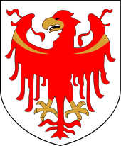
Coat-of-arms
The shield is party per pale of argent; the first part shows half Tyrolean eagle; the second part is tierced per fess of sable and argent. It is the arms of the Counts of Eschenlch and the Tyrolean eagle represents the membership to the Tirol. The emblem was granted in 1967.[2]
Society
Linguistic distribution
According to the 2011 census, 99.40% of the population speak German, 0.53% Italian and 0.07% Ladin as first language.[3]
Demographic evolution

- note: in 1897 the largest village of Ulten St. Pankraz became a Gemeinde on its own.
References
- ↑ All demographics and other statistics: Italian statistical institute Istat.
- ↑ Heraldry of the World: Ulten
- ↑ "Volkszählung 2011/Censimento della popolazione 2011". astat info (Provincial Statistics Institute of the Autonomous Province of South Tyrol) (38): 6–7. June 2012. Retrieved 2012-06-14.
External links
- (German) (Italian) Homepage of the municipality
![]() Media related to Ulten at Wikimedia Commons
Media related to Ulten at Wikimedia Commons