Ulster Way
| Ulster Way | |
|---|---|
|
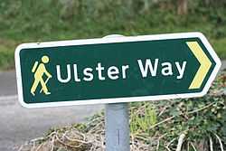
Ulster Way sign near Strangford, August 2009. | |
| Length | 625 miles (1,006 kilometres)[1] |
| Location |
Northern Ireland Republic of Ireland |
| Trailheads | Belfast |
| Use | Hiking |
| Hiking details | |
| Season | Any |
| Sights | Mourne Mountains, Fermanagh lakeland, Sperrin Mountains, Giant's Causeway |
| Surface | Mountain, field and cliff paths; roads. |
| Website | www.walkni.com/ulsterway |
The Ulster Way is a series of walking routes which encircle the Irish province of Ulster. It was originally founded in the 1970s by Wilfred Capper MBE, who was inspired by Tom Stephenson's Pennine Way.[2][3] The route was relaunched in 2009 by the Department of the Environment (Northern Ireland).
Most of the trail lies within Northern Ireland, the remainder being in the Republic of Ireland. The path visits many places of interest including the Mourne Mountains, Giant's Causeway, Cavehill and the Sperrins. Most of the sections are clearly sign-posted.
History
Wilfred Capper first developed the idea for the Ulster Way in 1946, as a waymarked trail that would pass through the six counties of Northern Ireland, linking 15 Youth Hostels which were in place at the time.[4] Once implemented, this original route stretched for 665 miles. After the development of the Way, Capper subsequently became the first person to complete the route.[4]
towards the end of the 20th century, large sections of the trail fell into disrepair or were "lost" due to increased car traffic on some of the road sections, and ambiguity of ownership and land access rights.[5]
In April 2003, Environment Minister Angela Smith MP announced a project to improve and maintain the Ulster Way.[6] A new route was agreed in early 2009.[7] The new route was officially opened on 16 September 2009. The new route was completed by Rick McKee and David Creighton, by bike, over 6 days in May 2008. This revised route is 625 miles; the revised route was first completed by schoolboys Matthew Hoper and Simon Harris.[3][8]
References
- ↑ "The Ulster Way". Department of the Environment (Northern Ireland). Retrieved 19 May 2012.
- ↑ Presenter: Clare Balding (2007-03-02). "The Ulster Way". Ramblings. BBC Radio 4.
- ↑ 3.0 3.1 "New Province-wide walking route launched". The News Letter. 2009-09-16. Retrieved 2009-10-11.
- ↑ 4.0 4.1 "History of the Ulster Way". walkni.com. Retrieved 19 May 2012.
- ↑ "The end of the road for NI walkway?". BBC News. 2002-03-20. Retrieved 2009-10-11.
- ↑ "Ulster Way update at May 2009". Northern Ireland Environment Agency. May 2009. Retrieved 2009-10-11.
- ↑ "History of the Ulster Way". WalkNI. Retrieved 2009-10-11.
- ↑ Stewart, Linda (2009-09-16). "Get your boots on, the Ulster Way is back on the map". Belfast Telegraph. Retrieved 2009-10-11.
| Wikimedia Commons has media related to Ulster Way. |
Further reading
Several books have been published as a guide to walking the route. Including:
- The Ulster Way, Paddy Dillon, The O'Brien Press, 1999, ISBN 0-86278-589-8
- Walking the Ulster Way, Alan Warner, Appletree Press, 1989, ISBN 0-86281-227-5
Coordinates: 55°15′00″N 6°29′06″W / 55.250°N 6.485°W