Ulldecona Dam
| Ulldecona Dam | |
|---|---|
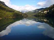 View of the reservoir | |
 | |
| Official name | Embassament d'Ulldecona |
| Country | Spain |
| Location | Pobla de Benifassà, Valencian Community, Spain |
| Coordinates | 40°40′15″N 0°13′52″E / 40.67083°N 0.23111°ECoordinates: 40°40′15″N 0°13′52″E / 40.67083°N 0.23111°E |
| Status | Operational |
| Opening date | 1967 |
| Dam and spillways | |
| Type of dam | Gravity dam |
| Impounds | Barranc de la Fou, Barranc de Teulatí and Barranc de la Pobla |
| Height | 54 m |
| Length | 180 m |
| Reservoir | |
| Total capacity | 11 Hm³ |
| Surface area | 817 ha |
The Ulldecona Dam, known locally as Embassament d'Ulldecona or Pantà d'Ulldecona (Spanish: Embalse de Ulldecona) is a gravity dam located in the Tinença de Benifassà and the Ports de Tortosa-Beseit mountains, within the La Pobla de Benifassà municipal limits, Valencian Community, Spain.[1]
Description
The reservoir is at the confluence of three seasonal rivers, the Barranc de la Fou, Barranc de Teulatí, also known as Barranc de la Tenalla, and the Barranc de la Pobla, all part of the Sénia River basin. The dam was built in 1967 and was financed by farmers from the town of Ulldecona, hence its name. Its reservoir reaches a surface of 817 ha with a capacity of 11 Hm³.[2] This dam belongs to the Hydrographic Confederation of the Xúquer (Confederación Hidrográfica del Júcar/Confederació Hidrogràfica del Xúquer).[3] The abandoned village of Mangraner is located at the northwestern end of the reservoir not far from the shore.
The dam attracts tourists, especially in the summer. Right by the reservoir there is a restaurant, accommodation, pedalos and information about hiking routes in the neighboring karstic mountainous area. The easiest way to reach the Ulldecona Dam is from La Sénia town located close by.
Gallery
-
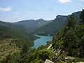
View of the Ulldecona reservoir in the summer
-
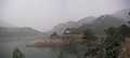
A winter snowstorm over the Ulldecona Dam
References
External links
 Media related to Ulldecona Dam at Wikimedia Commons
- Ulldecona Tourism