Ujjain district
This article is about the district.
For its eponymous headquarters, see
Ujjain.
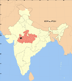
Ujjain District is a district of Madhya Pradesh state in central India. The historic city of Ujjain is the district headquarters.
The district has an area of 6,091 km², and a population of 1,709,885 (2001 census), a 24% increase from its 1991 population of 1,386,465. The district is bounded by the districts of Shajapur on the northeast and east, Dewas to the southeast, Indore to the south, Dhar to the southwest, and Ratlam to the west and northwest. The district is part of Ujjain Division.
Demographics
According to the 2011 census Ujjain District has a population of 1,986,597,[1] roughly equal to the nation of Slovenia[2] or the US state of New Mexico.[3] This gives it a ranking of 233rd in India (out of a total of 640).[1] The district has a population density of 326 inhabitants per square kilometre (840/sq mi) .[1] Its population growth rate over the decade 2001-2011 was 16.11%.[1] Ujjain has a sex ratio of 954 females for every 1000 males,[1] and a literacy rate of 73.55%.[1]
References
External links
|
|---|
| | | | State symbols | |
|---|
| | Governance | |
|---|
| | Divisions |
- Bhopal
- Morena
- Gwalior
- Indore
- Jabalpur
- Hoshangabad
- Rewa
- Sagar
- Shahdol
- Ujjain
|
|---|
| | Districts | |
|---|
| | Major cities | |
|---|
|
Coordinates: 23°25′N 75°30′E / 23.417°N 75.500°E / 23.417; 75.500