Ucolo, Utah
| Ucolo | |
|---|---|
| Unincorporated community | |
 Ucolo Location within the state of Utah | |
| Coordinates: 37°51′39″N 109°3′53″W / 37.86083°N 109.06472°WCoordinates: 37°51′39″N 109°3′53″W / 37.86083°N 109.06472°W | |
| Country | United States |
| State | Utah |
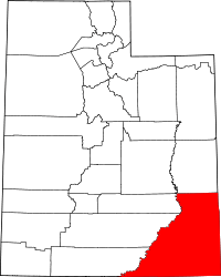
| County | San Juan |
| Named for | Portmanteau of Utah and Colorado |
| Elevation[1] | 6,762 ft (2,061 m) |
| Time zone | Mountain (MST) (UTC-7) |
| • Summer (DST) | MDT (UTC-6) |
| ZIP code | 84512 |
| Area code(s) | 435 |
| GNIS feature ID | 1455156[1] |
| Historical population | |||
|---|---|---|---|
| Census | Pop. | %± | |
| 1940 | 224 | — | |
| 1950 | 379 | 69.2% | |
| Source: U.S. Census Bureau[2] | |||
Ucolo is an unincorporated community locale in San Juan County, Utah. It is located close to the Colorado border, and its name is a portmanteau of Utah and Colorado. The nearest major highway is U.S. Route 491, and the nearest established settlement is Egnar, Colorado.
References
- ↑ 1.0 1.1 U.S. Geological Survey Geographic Names Information System: Ucolo, Utah. Retrieved May 19, 2011.
- ↑ "Census of Population and Housing". U.S. Census Bureau. Retrieved November 7, 2011.
| |||||||||||||||||||||||||||||||||