U.S. Route 45 in Michigan
| ||||
|---|---|---|---|---|
|
US 45 highlighted in red | ||||
| Route information | ||||
| Maintained by MDOT | ||||
| Length: | 54.759 mi[1] (88.126 km) | |||
| Existed: | c. 1935[2][3] – present | |||
| Major junctions | ||||
| South end: |
| |||
|
| ||||
| North end: | Ontonagon & River streets in Ontonagon | |||
| Location | ||||
| Counties: | Gogebic, Ontonagon | |||
| Highway system | ||||
| ||||
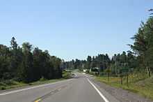
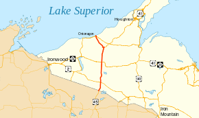
US Highway 45 (US 45) is a part of the United States Numbered Highway System that runs from Mobile, Alabama, to the Upper Peninsula (UP) of the US state of Michigan. The highway forms a part of the state trunkline highway system that is maintained by the Michigan Department of Transportation (MDOT). It enters the state from Wisconsin south of Watersmeet, ending at an intersection with Ontonagon Street in Ontonagon. In between, the roadway crosses the UP running for approximately 54 3⁄4 miles (88.1 km) through the Ottawa National Forest and parallel to the Ontonagon River.
The highway dates back to the 1930s in Michigan. At the time it was extended into the state, it replaced sections of M-26 and M-35. An eight-mile (13 km) segment was significantly reconstructed in the late 1950s, and an alignment change in the 1970s moved the routing of US 45 near Rockland before it was reversed soon afterwards. A segment of roadway that formerly carried US 45 is the site of the Paulding Light, a local phenomenon whose origins were scientifically described in 2010.
Route description

US 45 crosses from Wisconsin to Michigan near Land O' Lakes, Wisconsin, east of the Sylvania Wilderness area of the Ottawa National Forest. The highway angles northeast from the state line before curving around to the north toward Watersmeet, where it intersects US 2. Watersmeet is home to the northern section of the Lac Vieux Desert Indian Reservation. Continuing north across the Gogebic–Ontonagon county line, US 45 crosses the boundary between the Central and Eastern time zones.[4][5]
In southern Ontonagon County, the highway runs west of the Bond Falls Flowage near Paulding. North of here, the trunkline enters Bruce Crossing and intersects M-28. After leaving town, US 45 runs northward parallel to the Middle Branch of the Ontonagon River, and the highway crosses the river near a roadside park south of Rockland. East of Rockland, US 45 meets the southern terminus of M-26; after the intersection, US 45 turns northwesterly and runs parallel to the Ontonagon River[4][5] and a branch of the Escanaba and Lake Superior Railroad (ELS).[6]
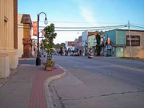
US 45 enters the south side of Ontonagon on Rockland Road near the Holy Family Cemetery. The roadway turns due north and crosses the ELS rail line, still running parallel to the course of the river. South of downtown, the highway crosses an intersection that serves as the joint termini of M-38 and M-64. M-64 crosses the river from the west on a bridge built in 2006 and ends at the intersection.[7][8] M-38 comes into town from the east and also ends at the same intersection. US 45 continues north on Rockland Road and turns northwest on River Street along the eastern river bank through downtown. The northern terminus of US 45 is at Ontonagon Street, about 1,000 feet (300 m) from Lake Superior.[7]
History
US 45 debuted in Michigan by 1935 on maps of the time. The highway previously terminated in Des Plaines, Illinois, until it was extended northward to Michigan.[9] US 45 replaced M-26 between the state line north toward Rockland, as well as M-35 between Rockland and Ontonagon.[2][3] The Michigan State Highway Department (MSHD) rebuilt an eight-mile (13 km) section of the highway in the Military Hills area of eastern Ontonagon County starting in 1957. As part of the project, tons of waste copper rock were hauled into the area to provide a base for the reconstructed roadway, which was previously quite steep through the hills and muddy during rains.[10] The project included a new bridge over the Ontonagon River that opened in late 1959. Along with this bridge, the last eight miles (13 km) of US 45 in the country were paved, connecting the Gulf of Mexico and Lake Superior with a hard-surfaced road.[11]

A rerouting in late 1971 moved the US 45 designation along M-26 between Rockland and Greenland. From Greenland, US 45 followed Ontonagon–Greenland Road to Ontonagon.[12][13] In late 1973, MDOT reversed the rerouting—US 45 was restored to its previous routing on Rockland Road between Rockland and Ontonagon and M-26 was re-extended south from Greenland to Rockland; M-38 was extended west along Ontonagon–Greenland Road.[14][15]
In 2010, students from Michigan Technological University solved the mystery of the Paulding Light, a local phenomenon commonly attributed to paranormal activity.[16] The phenomenon is viewable from a section of Robbins Pond Road, the former routing of US 45 in the Paulding area.[17] According to area folklore, and indicated on signs in the viewing area, the light is from the ghost of a railroad brakeman. Other explanations say the light comes from a ghost train from the 1800s.[18] The students' investigation showed that the light comes from headlights of cars on US 45 in the Paulding area.[16]
Major intersections
| County | Location | mi[1] | km | Destinations | Notes |
|---|---|---|---|---|---|
| Gogebic | Watersmeet Township | 0.000 | 0.000 | Wisconsin state line | |
| Watersmeet | 7.522 | 12.105 | |||
| Ontonagon | Bruce Crossing | 26.668 | 42.918 | ||
| Rockland Township | 40.524 | 65.217 | Southern terminus of M-26 | ||
| Ontonagon | 54.094 | 87.056 | Western terminus of M-38; northern terminus of M-64 | ||
| 54.759 | 88.126 | Ontonagon Street | Northern terminus of US 45 | ||
| 1.000 mi = 1.609 km; 1.000 km = 0.621 mi | |||||
See also
- Michigan Highways portal
References
- ↑ 1.0 1.1 Michigan Department of Transportation & Michigan Center for Shared Solutions and Technology Partnerships (2009). MDOT Physical Reference Finder Application (Map). Michigan Department of Transportation. Retrieved March 23, 2010.
- ↑ 2.0 2.1 Michigan State Highway Department & Rand McNally (September 1, 1934). Official Michigan Highway Map (Map). Scale not given. Lansing: Michigan State Highway Department.
- ↑ 3.0 3.1 Michigan State Highway Department & Rand McNally (May 15, 1935). Official Michigan Highway Map (Map). Scale not given. Lansing: Michigan State Highway Department.
- ↑ 4.0 4.1 Michigan Department of Transportation (2009). Official Department of Transportation Map (Map). 1 in≈15 mi / 1 cm≈9 km. Lansing: Michigan Department of Transportation. §§ B3–D3.
- ↑ 5.0 5.1 Rand McNally (2008). "Michigan" (Map). The Road Atlas. 1 in:30 mi. Chicago: Rand McNally. pp. 50–51. Western Upper Peninsula inset. §§ A12–C12.
- ↑ Ashcraft, Stacey (September 29, 2009). "Ontonagon Could Lose Rail Service". The Daily Mining Gazette (Houghton, MI). Retrieved March 25, 2010.
- ↑ 7.0 7.1 Google (July 30, 2009). "Ontonagon, MI" (Map). Google Maps. Google. Retrieved July 30, 2009.
- ↑ Lake, James (October 10, 2006). "New Ontonagon River Bridge to Open Oct. 11" (Press release). Michigan Department of Transportation. Retrieved August 2, 2009.
- ↑ Illinois Automobile Department (1934). Official 1934 Road Map of Illinois (Map). c. 1:950,000 and c. 1:1,110,000. Cartography by Rand McNally. Springfield: Illinois Automobile Department. §§ A6–A7. Retrieved October 28, 2013 – via Illinois Digital Archives.
- ↑ "Motorcades Meet at US 45 Bridge". The Daily Mining Gazette (Houghton, MI). November 4, 1959. p. 1. OCLC 9940134.
- ↑ "Bridge, 8 Miles of US 45 Opened near Ontonagon". Milwaukee Sentinel. November 4, 1959. p. 1, part 2. ISSN 1052-4479. Retrieved March 29, 2011.
- ↑ Michigan Department of State Highways (1971). Official Highway Map (Map). 1 in≈14.5 mi. Lansing: Michigan Department of State Highways. §§ B2–B3. OCLC 77960415.
- ↑ Michigan Department of State Highways (1972). Official Highway Map (Map). 1 in≈14.5 mi. Lansing: Michigan Department of State Highways. §§ B2–B3.
- ↑ Michigan Department of State Highways (1973). Official Highway Map (Map). 1 in≈14.5 mi. Lansing: Michigan Department of State Highways. §§ B2–B3. OCLC 81679137.
- ↑ Michigan Department of State Highways and Transportation (1974). Official Transportation Map (Map). 1 in≈14.5 mi. Lansing: Michigan Department of State Highways and Transportation. §§ B2–B3. OCLC 83138602.
- ↑ 16.0 16.1 Kukkonen, Stacey (November 2, 2010). "Tech Students Claim To Debunk Paulding Light Mystery". The Daily Mining Gazette (Houghton, MI). Retrieved May 15, 2013.
- ↑ Staff. "Paulding Mystery Light". Porcupine Mountains Ontonagon Area Convention and Visitors Bureau. Retrieved December 3, 2013.
- ↑ Barrett, Nate (October 31, 2012). "The Paulding Light: A Mystery that Haunts Michigan's UP". Wausau, WI: WFXS-TV. Retrieved October 29, 2013.
External links
| Wikimedia Commons has media related to US 45 in Michigan. |
Route map: Bing
- US 45 at Michigan Highways
| Previous state: Wisconsin |
Michigan | Next state: Terminus |

