U.S. Route 371
| ||||||||||
|---|---|---|---|---|---|---|---|---|---|---|
|
US 371 highlighted in red | ||||||||||
| Route information | ||||||||||
| Auxiliary route of US 71 | ||||||||||
| Maintained by LaDOTD and AHTD | ||||||||||
| Length: | 214 mi (344 km) | |||||||||
| Existed: | 1994[1] – present | |||||||||
| Major junctions | ||||||||||
| South end: |
| |||||||||
|
| ||||||||||
| North end: |
| |||||||||
| Highway system | ||||||||||
| ||||||||||

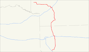
U.S. Route 371 is a north–south United States highway in the U.S. states of Arkansas and Louisiana. The highway's northern terminus is in De Queen, Arkansas at an intersection with U.S. Highway 70. It is co-signed for its last 13 miles (21 km) between Lockesburg, Arkansas and DeQueen with U.S. Highway 59 and U.S. Highway 71. Its southern terminus is 5 miles (8.0 km) west of Coushatta, Louisiana at an intersection with Interstate 49.
Route description
Louisiana
U.S. 371 is an afterthought in the federal highway system. Within Louisiana it was merely the 1990s renumbering and re-signing of the post-1955 Louisiana Highway 7, which after the 1990s change ceased to exist as a number for a state highway in Louisiana. Although signage is on I-49, US 371 begins just north of Coushatta, Louisiana at an intersection with US 71. Intersecting I-20 and US 80 at Minden, it then crosses the Arkansas Line at Springhill, Louisiana.
Arkansas
US 371 contains about 134 miles (216 km) in South Arkansas.
US 371 enters Arkansas in Columbia County. The route runs north to intersect AR 160 in Taylor and winds east to Magnolia. A concurrency with US 82 begins in Magnolia, and continues north to the city limits. US 371 continues west to meet AR 98 in Waldo, before heading north to enter Nevada County. The route next meets AR 32 and AR 76 before entering Rosston, where a short concurrency with US 278 forms. US 371 meets AR 372 before entering Prescott, where the route runs with AR 24 and is intersected by Interstate 30 before entering Hempstead County.
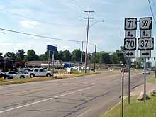
US 371 winds through Hempstead County west and north, concurring briefly with AR 195 and eventually entering Howard County. The route passes through Nashville, again meeting US 278, and runs west through rural land and into Sevier County. In Sevier County, US 371 meets US 59/US 71, which form a northern concurrency, eventually adding US 70 as well. These four routes run together west to De Queen, at which US 371 terminates.
History
US 371 was established along its current routing in 1994, after having been decommissioned in Minnesota in 1973. The decommissioned route in Minnesota still bears the name of MN 371, which is one of the few Minnesota state routes that doesn't follow the normal numbering convention for state highways.
Major intersections
| State | County | Location | mi | km | Destinations | Notes |
|---|---|---|---|---|---|---|
| Louisiana | DeSoto | I-49 exit 162; south end of LA 177 overlap | ||||
| Evelyn | ||||||
| Red River | north end of LA 177 overlap | |||||
| Armistead | south end of US 84 overlap | |||||
| Coushatta | north end of US 84 overlap | |||||
| south end of US 71 overlap | ||||||
| north end of US 71 overlap | ||||||
| south end of LA 514 overlap | ||||||
| north end of LA 514 overlap | ||||||
| Bienville | Woodardville | |||||
| Ringgold | south end of LA 4 / LA 154 overlap | |||||
| south end of LA 4 / LA 154 overlap | ||||||
| Davis | ||||||
| Webster | ||||||
| Sibley | ||||||
| Minden | south end of I-20 overlap; US 371 south follows exit 47 | |||||
| north end of I-20 overlap; US 371 north follows exit 44 | ||||||
| Dixie Inn | ||||||
| Cotton Valley | ||||||
| Sarepta | ||||||
| Porterville | ||||||
| Springhill | ||||||
| Arkansas | Columbia | Taylor | 5.70 | 9.17 | south end of AR 160 overlap | |
| 5.83 | 9.38 | north end of AR 160 overlap | ||||
| 21.95 | 35.33 | |||||
| Magnolia | 25.16 | 40.49 | ||||
| 27.23 | 43.82 | |||||
| Waldo | 31.45 | 50.61 | south end of AR 98 overlap | |||
| 32.57 | 52.42 | north end of AR 98 overlap | ||||
| Lamartine | 35.58 | 57.26 | ||||
| Nevada | Willisville | 44.11 | 70.99 | |||
| Irma | 46.80 | 75.32 | ||||
| Rosston | 49.28 | 79.31 | south end of US 278 overlap | |||
| 49.70 | 79.98 | |||||
| 50.16 | 80.72 | north end of US 278 overlap | ||||
| Laneburg | ||||||
| south end of AR 299 overlap | ||||||
| north end of AR 299 overlap | ||||||
| Prescott | south end of US 67 overlap | |||||
| north end of US 67 overlap | ||||||
| I-30 exit 44 | ||||||
| Hempstead | ||||||
| Blevins | ||||||
| Dotson | ||||||
| Howard | Nashville | south end of US 278 overlap | ||||
| north end of US 278 overlap | ||||||
| Sevier | Lockesburg | south end of US 59 / US 71 overlap | ||||
| south end of US 70 overlap | ||||||
| De Queen | north end of US 59 / US 70 / US 71 overlap | |||||
1.000 mi = 1.609 km; 1.000 km = 0.621 mi
| ||||||
See also
Related routes:
References
- ↑ Droz, Robert V. U.S. Highways : From US 1 to (US 830). URL accessed 19 March 2006.